CloudsThe nature of cloudsA classification of clouds was introduced by Luke Howard (1772-1864) who usedLatinwordstodescribetheircharacteristics.Cirrus -a tuft or filament (e.g. of hair)Cumulus-aheaporpileStratus-a layer.Nimbus-rain bearingThere are nowten basiccloudtypeswith names basedon combinationsofthesewords (the word'alto',meaning high but now used to denote medium-level doud, isalso used).Clouds form when moist air is cooled to such an extent that it becomes saturated. The main mechanismfor cooling airis to force it to rise. As air rises it expands - because the pressure decreases through theatmosphere-andthereforecools.Eventuallyitmaybecomesaturatedandthewatervapourthencondenses into tiny water droplets, similar in size to those found in fog, and forms cloud. If thetemperaturereaches below about -2o C,many ofthe cloud droplets will havefrozen so that the cloudis mainly composed of ice crystals.Themainwaysinwhichairrisestoform cloud1.Rapid local ascent when heated air at the earth's surfacerises in theform of thermal currents(convection).2.Slow, widespread,mass ascent where warm moistair is undercut by cold air (the barrier between thewarm and cold air is called a 'front').3.Upward motionassociated with turbulenteddies resultingfromthefrictional effectof the earth'ssurface.4.Airforcedtoriseoverabarrierofmountainsorhills
Clouds The nature of clouds A classification of clouds was introduced by Luke Howard (1772-1864) who used Latin words to describe their characteristics. ▪ Cirrus - a tuft or filament (e.g. of hair) ▪ Cumulus - a heap or pile ▪ Stratus - a layer ▪ Nimbus - rain bearing There are now ten basic cloud types with names based on combinations of these words (the word 'alto', meaning high but now used to denote medium-level cloud, is also used). Clouds form when moist air is cooled to such an extent that it becomes saturated. The main mechanism for cooling air is to force it to rise. As air rises it expands - because the pressure decreases through the atmosphere - and therefore cools. Eventually it may become saturated and the water vapour then condenses into tiny water droplets, similar in size to those found in fog, and forms cloud. If the temperature reaches below about -20 °C, many of the cloud droplets will have frozen so that the cloud is mainly composed of ice crystals. The main ways in which air rises to form cloud 1. Rapid local ascent when heated air at the earth's surface rises in the form of thermal currents (convection). 2. Slow, widespread, mass ascent where warm moist air is undercut by cold air (the barrier between the warm and cold air is called a 'front'). 3. Upward motion associated with turbulent eddies resulting from the frictional effect of the earth's surface. 4. Air forced to rise over a barrier of mountains or hills
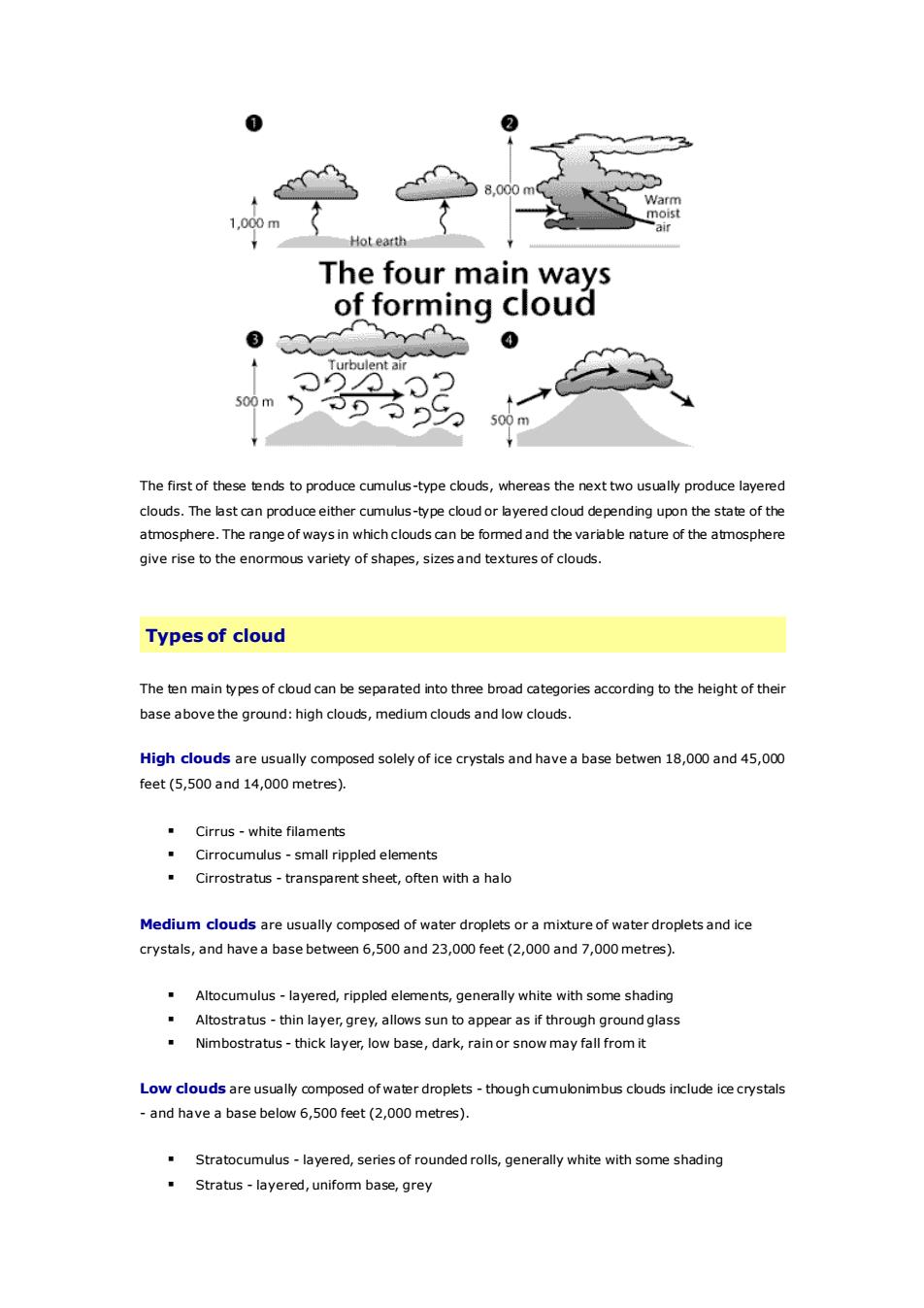
2Warmmoist1.000mfoteartiThefourmainwaysofformingcloud03Turbullentai500500rThe first of these tends to produce cumulus-type clouds, whereas the next two usually produce layeredclouds.The last can produceeither cumulus-type cloudor layered cloud depending upon the state of theatmosphere.The range of ways in whichclouds can be formedand the variable nature of the atmospheregive rise to the enormous variety of shapes, sizes and textures of clouds.Types of cloudThetenmaintypesofcloudcanbeseparated intothreebroad categoriesaccordingtotheheightoftheirbaseabovetheground:high clouds,medium clouds and low clouds.High clouds are usually composed solely ofice crystals and havea basebetwen 18,000 and 45,000feet(5,500 and14,000 metres).Cirrus-whitefilamentsCirrocumulus-small rippled elementsCirrostratus-transparentsheet, oftenwithahaloMedium cloudsareusually composed of water droplets ora mixture of waterdroplets and icecrystals,and haveabasebetween6,500and23,000feet(2,000and7,000metres).Altocumulus-layered,rippledelements,generallywhitewithsomeshadingAltostratus-thinlayer,grey,allows sun toappear as if through groundglassNimbostratus -thick layer, low base,dark,rainor snow mayfall from itLow clouds areusualy composed of waterdroplets-thoughcumulonimbus clouds include icecrystals-and haveabasebelow6,500feet (2,000metres).Stratocumulus-layered, series of roundedrolls,generallywhite with some shadingStratus -layered,unifom base, grey
The first of these tends to produce cumulus-type clouds, whereas the next two usually produce layered clouds. The last can produce either cumulus-type cloud or layered cloud depending upon the state of the atmosphere. The range of ways in which clouds can be formed and the variable nature of the atmosphere give rise to the enormous variety of shapes, sizes and textures of clouds. Types of cloud The ten main types of cloud can be separated into three broad categories according to the height of their base above the ground: high clouds, medium clouds and low clouds. High clouds are usually composed solely of ice crystals and have a base betwen 18,000 and 45,000 feet (5,500 and 14,000 metres). ▪ Cirrus - white filaments ▪ Cirrocumulus - small rippled elements ▪ Cirrostratus - transparent sheet, often with a halo Medium clouds are usually composed of water droplets or a mixture of water droplets and ice crystals, and have a base between 6,500 and 23,000 feet (2,000 and 7,000 metres). ▪ Altocumulus - layered, rippled elements, generally white with some shading ▪ Altostratus - thin layer, grey, allows sun to appear as if through ground glass ▪ Nimbostratus - thick layer, low base, dark, rain or snow may fall from it Low clouds are usually composed of water droplets - though cumulonimbus clouds include ice crystals - and have a base below 6,500 feet (2,000 metres). ▪ Stratocumulus - layered, series of rounded rolls, generally white with some shading ▪ Stratus - layered, uniform base, grey
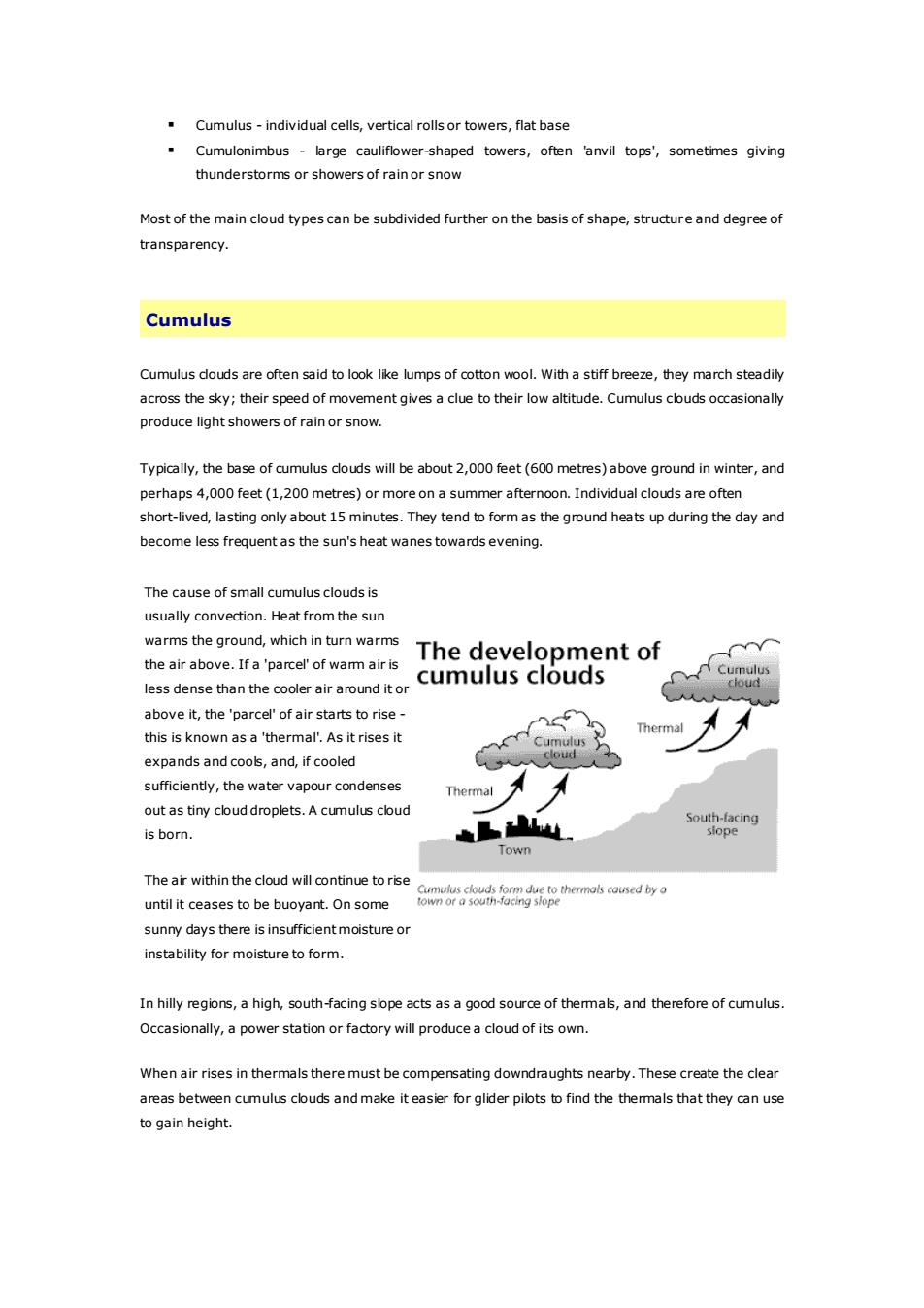
Cumulus-individual cells,vertical rolls or towers,flat baseCumulonimbus- large cauliflower-shaped towers, often 'anvil tops', sometimes givingthunderstorms or showers of rain or snowMostofthemain cloudtypescanbesubdividedfurtheronthebasis of shape,structureanddegreeoftransparency.CumulusCumuluscloudsareoftensaidtolooklikelumpsofcottonwool.Withastiffbreeze,theymarchsteadilyacross thesky; theirspeedof movementgives a clue to their lowaltitude.Cumulus cloudsoccasionallyproducelightshowersofrainorsnowTypically,the base of cumulus clouds will be about 2,o00 feet (600 metres)above ground in winter,andperhaps 4,000 feet (1,200 metres) or more on a summer afternoon. Individual clouds are oftenshort-lived, lasting only about 15 minutes. They tend to form as the ground heats up during the day andbecome less frequent as the sun's heat wanes towards evening.The cause of small cumulus clouds isusually convection. Heat from the sunwarms the ground, which in turn warmsThedevelopmentofthe air above. Ifa'parcel'of wam air isCumuluscumuluscloudscioudless dense than the cooler air around it orabove it, the'parcel' of air starts to rise -Thermalthis is known as a 'thermal.As it rises itumuCoudexpandsandcools,and, ifcooledsufficiently,the watervapour condensesThermalout as tiny cloud droplets.A cumulus cloudSouth-facingslopeis born.TownTheair withinthecloudwill continuetoriseCumulus clouds form due to thermals cousedbyotown orasouth-facing slopeuntilitceasestobebuoyant.Onsomesunnydaysthereisinsufficientmoistureorinstabilityfor moistureto form.In hillyregions,ahigh, south-facing slopeacts asagood source of thermals,and thereforeofcumulus.Occasionally,a power station orfactorywill producea cloud of its own.When air rises in thermals theremust be compensating downdraughts nearby.These create the clearareas between cumulus clouds and make it easier for glider pilots to find the thermals that they can useto gain height
▪ Cumulus - individual cells, vertical rolls or towers, flat base ▪ Cumulonimbus - large cauliflower-shaped towers, often 'anvil tops', sometimes giving thunderstorms or showers of rain or snow Most of the main cloud types can be subdivided further on the basis of shape, structure and degree of transparency. Cumulus Cumulus clouds are often said to look like lumps of cotton wool. With a stiff breeze, they march steadily across the sky; their speed of movement gives a clue to their low altitude. Cumulus clouds occasionally produce light showers of rain or snow. Typically, the base of cumulus clouds will be about 2,000 feet (600 metres) above ground in winter, and perhaps 4,000 feet (1,200 metres) or more on a summer afternoon. Individual clouds are often short-lived, lasting only about 15 minutes. They tend to form as the ground heats up during the day and become less frequent as the sun's heat wanes towards evening. The cause of small cumulus clouds is usually convection. Heat from the sun warms the ground, which in turn warms the air above. If a 'parcel' of warm air is less dense than the cooler air around it or above it, the 'parcel' of air starts to rise - this is known as a 'thermal'. As it rises it expands and cools, and, if cooled sufficiently, the water vapour condenses out as tiny cloud droplets. A cumulus cloud is born. The air within the cloud will continue to rise until it ceases to be buoyant. On some sunny days there is insufficient moisture or instability for moisture to form. In hilly regions, a high, south-facing slope acts as a good source of thermals, and therefore of cumulus. Occasionally, a power station or factory will produce a cloud of its own. When air rises in thermals there must be compensating downdraughts nearby. These create the clear areas between cumulus clouds and make it easier for glider pilots to find the thermals that they can use to gain height
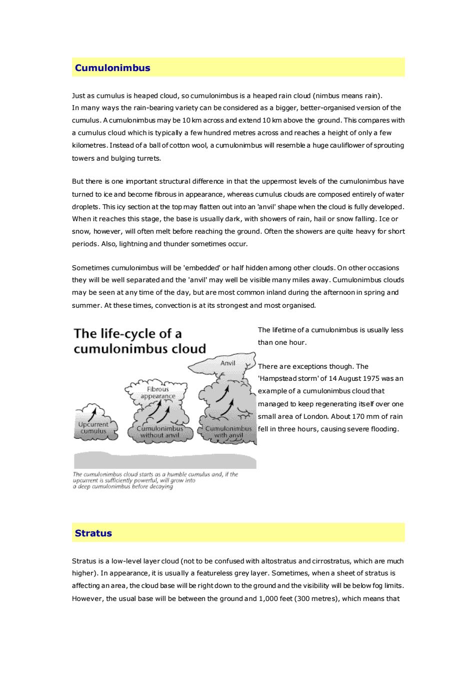
CumulonimbusJustascumulusisheapedcloud,socumulonimbusisaheapedraincloud(nimbusmeansrain),Inmanywaystherain-bearingvarietycanbeconsideredasabigger,better-organisedversionofthecumulus.Acumulonimbusmaybe10kmacross and extend 10kmabove theground.This compares witha cumulus cloud whichis typically afewhundred metres across andreaches a height of onlya fewkilometres.Instead ofa ball ofcotton wool, a cumulonimbus will resemblea huge cauliflowerof sproutingtowers and bulging turrets.Butthereisoneimportantstructuraldifferenceinthattheuppemostlevelsofthecumulonimbushaveturned to ice and become fibrous in appearance, whereas cumulus clouds are composed entirely of waterdroplets.Thisicysectionatthetopmayflattenout intoan'anvil'shapewhenthecloudisfullydeveloped.Whenitreachesthisstage,thebaseisusuallydark,withshowersofrain,hailorsnowfalling.Iceorsnow,however,willoftenmeltbeforereachingtheqround.Oftentheshowersareguiteheavyforshortperiods.Also, lightningandthundersometimesoccur.Sometimes cumulonimbus will be'embedded'or half hiddenamong otherclouds.On otheroccasionsthey will be well separatedand theanvil'may well bevisiblemanymilesaway.Cumulonimbus cloudsmay be seen atanytime oftheday,but aremost common inland during theafternoonin spring andsummer.Atthesetimes,convection is atits strongestandmostorganised.The lifetime ofa cumulonimbus is usually lessThelife-cycleofathan onehour.cumulonimbuscloudAnvilThere are exceptions though. The"Hampsteadstorm'of14August1975wasanFibrouexampleofa cumulonimbus cloudthatmanagedtokeepregeneratingitselfoveronesmallareaof London.About170mmofrainCumulonimbusfellin threehours,causingsevereflooding.umuioBnDuscumuiuswithout anvwithanvilThecumulonimbuscloudstartsasahumblecumulusand,iftheupcurrentissufficientlypowerfu,willgrowntoodeep cumulonimbusbeforedecoyingStratusStratus is a low-level layercloud(not to be confused with altostratus and cirrostratus,whichare muchhigher).Inappearance,itisusuallyafeaturelessgreylayer.Sometimes,whenasheetofstratusisaffecting anarea,the cloud base will berightdown to the ground and the visibility will be below fog limits.However,theusual basewillbebetweenthegroundand1,000feet(300metres),whichmeansthat
Cumulonimbus Just as cumulus is heaped cloud, so cumulonimbus is a heaped rain cloud (nimbus means rain). In many ways the rain-bearing variety can be considered as a bigger, better-organised version of the cumulus. A cumulonimbus may be 10 km across and extend 10 km above the ground. This compares with a cumulus cloud which is typically a few hundred metres across and reaches a height of only a few kilometres. Instead of a ball of cotton wool, a cumulonimbus will resemble a huge cauliflower of sprouting towers and bulging turrets. But there is one important structural difference in that the uppermost levels of the cumulonimbus have turned to ice and become fibrous in appearance, whereas cumulus clouds are composed entirely of water droplets. This icy section at the top may flatten out into an 'anvil' shape when the cloud is fully developed. When it reaches this stage, the base is usually dark, with showers of rain, hail or snow falling. Ice or snow, however, will often melt before reaching the ground. Often the showers are quite heavy for short periods. Also, lightning and thunder sometimes occur. Sometimes cumulonimbus will be 'embedded' or half hidden among other clouds. On other occasions they will be well separated and the 'anvil' may well be visible many miles away. Cumulonimbus clouds may be seen at any time of the day, but are most common inland during the afternoon in spring and summer. At these times, convection is at its strongest and most organised. The lifetime of a cumulonimbus is usually less than one hour. There are exceptions though. The 'Hampstead storm' of 14 August 1975 was an example of a cumulonimbus cloud that managed to keep regenerating itself over one small area of London. About 170 mm of rain fell in three hours, causing severe flooding. Stratus Stratus is a low-level layer cloud (not to be confused with altostratus and cirrostratus, which are much higher). In appearance, it is usually a featureless grey layer. Sometimes, when a sheet of stratus is affecting an area, the cloud base will be right down to the ground and the visibility will be below fog limits. However, the usual base will be between the ground and 1,000 feet (300 metres), which means that
hilltopsmaybeobscuredbycloud.Sometimesstratuswill producedrizzle,snoworsnowgrains,particularlyoverhillsPerhaps themost important indication of its low altitude is its apparent rapid movement across the skyinanywindstrongerthanaflatcalm.Forexample,astratuscloudat500feet(150metres)movingat20 milesper hourwillappeartomovemuchfaster than altostratus with its baseat10,000 feet(3,000metres)movingat60milesperhour.An approximate guide to the height of stratus may be gained by measuring the relative humidity andsubtracting it from 100. The resulting number gives some idea of the heightof the low cloud in hundredsoffeet.Forexample,94%relativehumiditywouldindicatethatthestratusisabout600feet(180metres)abovethe ground.Inland, the base of any stratus willtend to lift slightly during the daytime and,in summer, will usuallydisperse completely unless associated with rain.On the coast, when a moist south-westerly airstreampersists,theremaybe no such respite.The highestfrequency of stratus occurs in the westernparts ofthe British Isles wheremoist south-westerlyairstreams areforced to rise over various ranges of hills.CirriformcloudsCirriform clouds (i.e. clouds from the cirrus family)are foundat high altitude, usually above 20,o00 feet(6,oo0 metres). They are composed of ice crystals. Three types of cloud make up the group: cirrus,cirrostratusand cirrocumulus.Cirrus itself is very common in the British Isles and throughout most of the world. It is thin, wispy andwhiteinappearance,anditsname,comingfromtheLatinwordfor'tuftofhair',givesagooddescriptionof the cloud. Another name for the cloud, 'mares tais', also conjures up an accurate image. Cirrus maybe hooked or straight depending on the airflow aloft. Sometimes it comes as a very dense patch which isleftoverfromtheanvil'cloudofa cumulonimbus that hasdisappeared.On otheroccasions,cirrus maybequiteextensivewhenassociatedwitha jet stream-thecloud canthen beseenmovingacross the sky,despite its great altitude.Aircraft condensation trails area form ofman-made cirrus.They cansometimes be seen in historical' films, to the delight of film buffs who enjoy spotting technicalinaccuracies.Cirrostratus is a fairly unifom sheet of thin cloud through which the sun or moon can be seen.Sometimes, if the cloud is thin, a bright ring of light (called a halo) surrounds the sun or moon. A layerof cirrostratus is often an indication of a deterioration in the weather.Cirrocumulus is often present in smallamounts along with cirrus, butrarely does it dominate the sky.Onthose occasions when it is widespread, a beautiful spectacle is created, especially at sunset. Theindividual clouds appear very small - often tiny rows of roughly spherical pear-like cloud elementsSometimestheyoccurinundulatingpatterms liketinyripples
hilltops may be obscured by cloud. Sometimes stratus will produce drizzle, snow or snow grains, particularly over hills. Perhaps the most important indication of its low altitude is its apparent rapid movement across the sky in any wind stronger than a flat calm. For example, a stratus cloud at 500 feet (150 metres) moving at 20 miles per hour will appear to move much faster than altostratus with its base at 10,000 feet (3,000 metres) moving at 60 miles per hour. An approximate guide to the height of stratus may be gained by measuring the relative humidity and subtracting it from 100. The resulting number gives some idea of the height of the low cloud in hundreds of feet. For example, 94% relative humidity would indicate that the stratus is about 600 feet (180 metres) above the ground. Inland, the base of any stratus will tend to lift slightly during the daytime and, in summer, will usually disperse completely unless associated with rain. On the coast, when a moist south-westerly airstream persists, there may be no such respite. The highest frequency of stratus occurs in the western parts of the British Isles where moist south-westerly airstreams are forced to rise over various ranges of hills. Cirriform clouds Cirriform clouds (i.e. clouds from the cirrus family) are found at high altitude, usually above 20,000 feet (6,000 metres). They are composed of ice crystals. Three types of cloud make up the group: cirrus, cirrostratus and cirrocumulus. Cirrus itself is very common in the British Isles and throughout most of the world. It is thin, wispy and white in appearance, and its name, coming from the Latin word for 'tuft of hair', gives a good description of the cloud. Another name for the cloud, 'mares tails', also conjures up an accurate image. Cirrus may be hooked or straight depending on the airflow aloft. Sometimes it comes as a very dense patch which is left over from the 'anvil' cloud of a cumulonimbus that has disappeared. On other occasions, cirrus may be quite extensive when associated with a jet stream - the cloud can then be seen moving across the sky, despite its great altitude. Aircraft condensation trails are a form of man-made cirrus. They can sometimes be seen in 'historical' films, to the delight of film buffs who enjoy spotting technical inaccuracies. Cirrostratus is a fairly uniform sheet of thin cloud through which the sun or moon can be seen. Sometimes, if the cloud is thin, a bright ring of light (called a halo) surrounds the sun or moon. A layer of cirrostratus is often an indication of a deterioration in the weather. Cirrocumulus is often present in small amounts along with cirrus, but rarely does it dominate the sky. On those occasions when it is widespread, a beautiful spectacle is created, especially at sunset. The individual clouds appear very small - often tiny rows of roughly spherical pear-like cloud elements. Sometimes they occur in undulating patterns like tiny ripples