CloudsContentsWhatcauses cloudsIvpes of cloudsLow cloudsMedium cloudsHigh cloudsWhatinfluencesthe colour of clouds?Whydocloudsstopgrowingupwards?Why are there no clouds on some days?Measuring cloudsThe formation of precipitationShort-answer questionsWhatcausescloudsA cloud is defined as'a visible aggregate ofminute droplets of water or particles of ice ora mixture ofboth floating in the free air'. Each droplet has a diameter of about a hundredth of a millimetre and eachcubic metre of air will contain 100 milion droplets. Because the droplets are so smal,they can remain inliquidformintemperaturesof-3oC.Ifso,theyarecalledsupercooleddropletsClouds at higher and extremely cold levels in the atmosphere are composed of ice crystals - these canbe abouta tenth of a millimetre long.Clouds form when the invisible water vapour in the air condenses into visible water droplets or icecrystals.For this to happen, the parcel of air must be saturated,i.e. unable to hold all the wateritcontains in vapour fom, so it starts to condense into a liquid orsolid form.Thereare two ways bywhichsaturation is reached.(a) By increasing the water content in the air,e.g. through evaporation, to a point where the air can holdno more.(b)Bycoolingtheairsothatitreachesitsdewpoint-thisisthetemperatureatwhichcondensationoccurs, and is unable to'hold'any more water.Figure 1 shows how there is a maximum amount of watervapour the air,at a given temperature, can hold. In general, the warmer the air, the more water vapourit can hold. Therefore,reducing its temperature decreases its ability to hold water vapour so thatcondensation occurs
Clouds Contents What causes clouds Types of clouds Low clouds Medium clouds High clouds What influences the colour of clouds? Why do clouds stop growing upwards? Why are there no clouds on some days? Measuring clouds The formation of precipitation Short-answer questions What causes clouds A cloud is defined as 'a visible aggregate of minute droplets of water or particles of ice or a mixture of both floating in the free air'. Each droplet has a diameter of about a hundredth of a millimetre and each cubic metre of air will contain 100 million droplets. Because the droplets are so small, they can remain in liquid form in temperatures of -30 °C. If so, they are called supercooled droplets. Clouds at higher and extremely cold levels in the atmosphere are composed of ice crystals — these can be about a tenth of a millimetre long. Clouds form when the invisible water vapour in the air condenses into visible water droplets or ice crystals. For this to happen, the parcel of air must be saturated, i.e. unable to hold all the water it contains in vapour form, so it starts to condense into a liquid or solid form. There are two ways by which saturation is reached. (a) By increasing the water content in the air, e.g. through evaporation, to a point where the air can hold no more. (b) By cooling the air so that it reaches its dew point — this is the temperature at which condensation occurs, and is unable to 'hold' any more water. Figure 1 shows how there is a maximum amount of water vapour the air, at a given temperature, can hold. In general, the warmer the air, the more water vapour it can hold. Therefore, reducing its temperature decreases its ability to hold water vapour so that condensation occurs
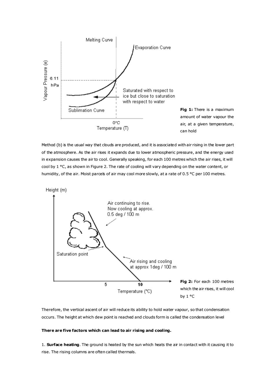
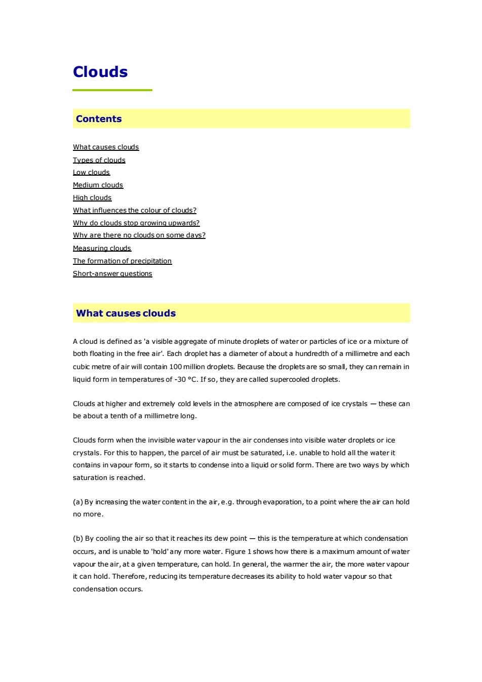
Melting CurveJEvaporationCurve(a)nssadnoden6.11hPaSaturatedwithrespecttoice but close to saturationwithrespecttowaterFig 1: There is a maximumSublimation Curve-amount of water vapour the0°℃air, at a given temperature,Temperature (T)can holdMethod (b) is the usual way that clouds are produced, and it is associated with air rising in the lower partof the atmosphere. As the air rises itexpands due to lower atmospheric pressure, and the energy usedin expansion causes the air to cool. Generally speaking,foreach 100 metres which the air rises, it willcoolby1oC,asshowninFigure2.Therateofcoolingwillvarydependingonthewatercontent,orhumidity,of theair.Moistparcelsofairmaycoolmoreslowly,atarateofo.5Cper100metres.Height (m)Air continuingto rise.Now coolingat approx.0.5 deg/100mSaturation pointAir rising and coolingatapprox1deg/100mFig 2: For each 100 metres510which the air rises, it will coolTemperature (°C)by 1°℃Therefore,theverticalascentofairwillreduceitsabilitytoholdwatervapour,sothatcondensationoccurs.TheheightatwhichdewpointisreachedandcloudsformiscalledthecondensationlevelTherearefivefactors which can lead to air rising and cooling.1.Surfaceheating.Theground isheatedbythesunwhichheatstheairincontactwithitcausingittorise.Therisingcolumnsareoftencalledthermals
Fig 1: There is a maximum amount of water vapour the air, at a given temperature, can hold Method (b) is the usual way that clouds are produced, and it is associated with air rising in the lower part of the atmosphere. As the air rises it expands due to lower atmospheric pressure, and the energy used in expansion causes the air to cool. Generally speaking, for each 100 metres which the air rises, it will cool by 1 °C, as shown in Figure 2. The rate of cooling will vary depending on the water content, or humidity, of the air. Moist parcels of air may cool more slowly, at a rate of 0.5 °C per 100 metres. Fig 2: For each 100 metres which the air rises, it will cool by 1 °C Therefore, the vertical ascent of air will reduce its ability to hold water vapour, so that condensation occurs. The height at which dew point is reached and clouds form is called the condensation level There are five factors which can lead to air rising and cooling. 1. Surface heating. The ground is heated by the sun which heats the air in contact with it causing it to rise. The rising columns are often called thermals
2.Topography.Airforced to rise over a barrier of mountains or hills.This is known as orographic uplift.3. Frontal.A mass of warmair rising up over a mass of cold, denseair.The boundary is calleda front.4.Convergence.Streams of airflowing from different directions are forced to rise where theymeet.5. Turbulence. A sudden change in wind speed with height creating turbulent eddies in the air.Another importantfactorto consider is that watervapourneeds something to condenseonto.Floating intheairaremillionsofminutesalt,dustandsmokeparticlesknownascondensationnucleiwhichenablecondensation totakeplacewhen theairis justsaturated.Typesof cloudsIn1803a retail chemistandamateurmeteorologist called Luke Howard proposed a system which hassubsequently become the basis of the present internationalclassification. Howard also become known bysome people as "the father of British meteorology",and his pioneering work stemmed from his curiousityintothevividsunsetsinthelate18thcenturyfollowingaseriesofviolentvolcaniceruptions.Theyhadejected dust high up into the atmosphere,thereby increasing the amount of condensation nuclei,andproducingspectacularcloudformationsand sunsets.Howard recognisedfourtypes ofcloud andgave them thefollowing Latin names:Cumulus heaped or in a pileStratus-in a sheetor layerCirrus - thread-like, hairy or curledNimbus-a rainbearerIf we includeanother Latin word altummeaningheight,thenames of the ten maincloudtypesareallderivedfromthesefivewordsandbasedupontheirappearancefromgroundlevelandvisualcharacteristics.The cloud types are split into threegroupsaccording to the height of their base abovemean sea level.Note that'medium'level clouds are prefixed by the word alto and'high'clouds by the word cirro (seeTable1).Allheightsgivenareapproximateabovesealevelinmid-latitudes.Ifobservingfromahilltopormountainsite,therangeofbaseswillaccordinglybelower.LowcloudsMedium cloudsHigh cloudsSurface-7,000ft7,000-17,000ft17,000-35,000ftCumulusAltocumulusCirrusCumulonimbusAltostratusCirrostratus
2. Topography. Air forced to rise over a barrier of mountains or hills. This is known as orographic uplift. 3. Frontal. A mass of warm air rising up over a mass of cold, dense air. The boundary is called a 'front'. 4. Convergence. Streams of air flowing from different directions are forced to rise where they meet. 5. Turbulence. A sudden change in wind speed with height creating turbulent eddies in the air. Another important factor to consider is that water vapour needs something to condense onto. Floating in the air are millions of minute salt, dust and smoke particles known as condensation nuclei which enable condensation to take place when the air is just saturated. Types of clouds In 1803 a retail chemist and amateur meteorologist called Luke Howard proposed a system which has subsequently become the basis of the present international classification. Howard also become known by some people as "the father of British meteorology", and his pioneering work stemmed from his curiousity into the vivid sunsets in the late 18th century following a series of violent volcanic eruptions. They had ejected dust high up into the atmosphere, thereby increasing the amount of condensation nuclei, and producing spectacular cloud formations and sunsets. Howard recognised four types of cloud and gave them the following Latin names: Cumulus — heaped or in a pile Stratus — in a sheet or layer Cirrus — thread-like, hairy or curled Nimbus — a rain bearer If we include another Latin word altum meaning height, the names of the ten main cloud types are all derived from these five words and based upon their appearance from ground level and visual characteristics. The cloud types are split into three groups according to the height of their base above mean sea level. Note that 'medium' level clouds are prefixed by the word alto and 'high' clouds by the word cirro (see Table 1). All heights given are approximate above sea level in mid-latitudes. If observing from a hill top or mountain site, the range of bases will accordingly be lower. Low clouds Surface - 7,000 ft Medium clouds 7,000 - 17,000 ft High clouds 17,000 - 35,000 ft Cumulus Altocumulus Cirrus Cumulonimbus Altostratus Cirrostratus
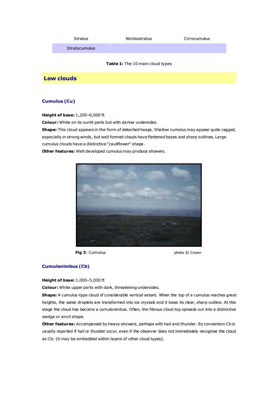
StratusNimbostratusCirrocumulusStratocumulusTable1:The10maincloudtypesLow cloudsCumulus(Cu)Heightofbase:1,200-6,000ftColour: White on its sunlit parts but with darker undersides.Shape:This cloud appears in the form of detached heaps.Shallow cumulusmayappear quite ragged,especiallyin strongwinds,butwellfomed clouds haveflattenedbases andsharpoutlines.Largecumulus clouds have a distinctive"cauliflower'shape.Otherfeatures:Well developed cumulusmayproduce showers.Fig3:Cumulusphoto CrownCumulonimbus(Cb)Heightof base:1,000-5,000ftColour: White upper parts with dark, threatening undersides.Shape: A cumulus-type cloud of considerable vertical extent. When the top of a cumulus reaches greatheights, the water droplets are transformed into ice crystals and it loses its clear,sharp outline. At thisstage the cloud has become a cumulonimbus. Often, the fibrous cloud top spreads out into a distinctivewedge oranvil shape.Otherfeatures:Accompaniedbyheavyshowers,perhapswithhailandthunder.ByconventionCbisusuallyreportedif hail orthunderoccur,eveniftheobserverdoesnotimmediatelyrecognisethecloudas Cb; (itmay be embedded within layers of other cloud types)
Stratus Nimbostratus Cirrocumulus Stratocumulus Table 1: The 10 main cloud types Low clouds Cumulus (Cu) Height of base: 1,200–6,000 ft Colour: White on its sunlit parts but with darker undersides. Shape: This cloud appears in the form of detached heaps. Shallow cumulus may appear quite ragged, especially in strong winds, but well formed clouds have flattened bases and sharp outlines. Large cumulus clouds have a distinctive "cauliflower" shape. Other features: Well developed cumulus may produce showers. Fig 3: Cumulus photo © Crown Cumulonimbus (Cb) Height of base: 1,000–5,000 ft Colour: White upper parts with dark, threatening undersides. Shape: A cumulus-type cloud of considerable vertical extent. When the top of a cumulus reaches great heights, the water droplets are transformed into ice crystals and it loses its clear, sharp outline. At this stage the cloud has become a cumulonimbus. Often, the fibrous cloud top spreads out into a distinctive wedge or anvil shape. Other features: Accompanied by heavy showers, perhaps with hail and thunder. By convention Cb is usually reported if hail or thunder occur, even if the observer does not immediately recognise the cloud as Cb; (it may be embedded within layers of other cloud types)
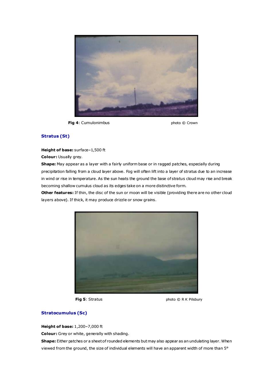
Fig4:Cumulonimbusphoto CrownStratus(St)Heightofbase:surface-1,500ftColour: Usually grey.Shape: May appearas a layer with a fairly uniform base or in ragged patches, especially duringprecipitation falling from a cloud layer above.Fog will often lift into a layer of stratus due to an increasein wind or rise in temperature.As the sun heats the ground the base ofstratus cloudmay riseand breakbecomingshallowcumuluscloudasitsedgestakeonamoredistinctiveformOtherfeatures:Ifthin,thediscofthesunormoonwillbevisible(providingtherearenoothercloudlayersabove).Ifthick, itmayproducedrizzleorsnowgrains.Fig5:Stratusphoto @ R K PilsburyStratocumulus(Sc)Heightofbase:1,200-7,000ftColour:Greyorwhite, generallywithshadingShape: Eitherpatches ora sheetof roundedelements butmayalso appearas an undulating layer.Whenviewedfromtheground,thesizeofindividualelementswillhaveanapparentwidthofmorethan5o
Fig 4: Cumulonimbus photo © Crown Stratus (St) Height of base: surface–1,500 ft Colour: Usually grey. Shape: May appear as a layer with a fairly uniform base or in ragged patches, especially during precipitation falling from a cloud layer above. Fog will often lift into a layer of stratus due to an increase in wind or rise in temperature. As the sun heats the ground the base of stratus cloud may rise and break becoming shallow cumulus cloud as its edges take on a more distinctive form. Other features: If thin, the disc of the sun or moon will be visible (providing there are no other cloud layers above). If thick, it may produce drizzle or snow grains. Fig 5: Stratus photo © R K Pilsbury Stratocumulus (Sc) Height of base: 1,200–7,000 ft Colour: Grey or white, generally with shading. Shape: Either patches or a sheet of rounded elements but may also appear as an undulating layer. When viewed from the ground, the size of individual elements will have an apparent width of more than 5°