AirmassesReturninbolaremaritmeair万衣AirmassesThe idea that northerly winds (i.e. winds from the north)are cold,and southerly winds (those from the south)are warm (at least in thenorthem hemisphere)is quite common.Similarly,airthathas travelled overtheseapicks upmoisture,whileairtravelling over thelandis relativelydry.Thesesimpleconceptshelp in theunderstanding of airmasses.In polarand subtropical regionstherearelarge semi-pemanentanticyclones(highpressureareas).Theairresides inthesesystemsfora long time and is gradually influenced by the underlying surface -air at the poles is cooled and air in the tropics is wamed.The result isa large body of airwith little horizontal variation in temperature and moisture content.Sometimes there is a large outflow of air from the anticyclones, and these air masses mayapproachthe BritishIsles (usuallypolarair fromthenorthandtropicalairfromthesouth).However,ontheirjourneytheymaybemodifiedbycontactwiththeunderlyingsurface.Airthattravelsoverthesea(maritimeair)ismoistened,whereasthereis littlechangeinmoisturecontentofairthattravelsovertheland(continentalair).Forexample,airthathasbeentrappedinananticycloneovertheSaharainJuneslowlyheatsupanddries.Afterawhilethe air moves out of theanticyclone and may headfor the British Isles.On its way it may collect moisture over the Mediterranean Sea, butthe journey overSpain and France has little effect on its properties.The air then arrives here as a hot, dryair mass
Air masses Air masses The idea that northerly winds (i.e. winds from the north) are cold, and southerly winds (those from the south) are warm (at least in the northern hemisphere) is quite common. Similarly, air that has travelled over the sea picks up moisture, while air travelling over the land is relatively dry. These simple concepts help in the understanding of air masses. In polar and subtropical regions there are large semi-permanent anticyclones (high pressure areas). The air resides in these systems for a long time and is gradually influenced by the underlying surface - air at the poles is cooled and air in the tropics is warmed. The result is a large body of air with little horizontal variation in temperature and moisture content. Sometimes there is a large outflow of air from the anticyclones, and these air masses may approach the British Isles (usually polar air from the north and tropical air from the south). However, on their journey they may be modified by contact with the underlying sur face. Air that travels over the sea (maritime air) is moistened, whereas there is little change in moisture content of air that travels over the land (continental air). For example, air that has been trapped in an anticyclone over the Sahara in June slowly heats up and dries . After a while, the air moves out of the anticyclone and may head for the British Isles. On its way it may collect moisture over the Mediterranean Sea, but the journey over Spain and France has little effect on its properties. The air then arrives here as a hot, dry air mass
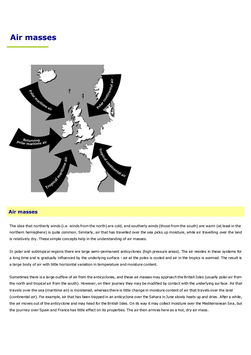
Air masses affecting the British Isles can be broadly categorised in tems of their source and their path. This leads to four pos sible types.Tropicalmaritime-warmandmoist-Tropical continental - warm and dryPolarmaritime-coldand (fairly)moist--Polar continental - cold and dryTo these must be added another air mass - returning polar maritime - which consists of polar air that has moved southwards over the seaand then turns northwards andapproachesthe BritishIslesfromthesouth.In reality,the type of air mass affecting the British Isles only gives an indication of the type of weather that may occur.The actual weatherdepends upon the detailed history of theair,the speed ofmovement and the surface over which itflowsThe boundary between two different types of air mass is referred to as a front. It is common for the British Isles to be affected by sequencesof fronts; theseusually separating polarmaritimeand tropicalmaritimeair.Tropicalcontinental
Air masses affecting the British Isles can be broadly categorised in terms of their source and their path. This leads to four pos sible types. ▪ Tropical maritime - warm and moist ▪ Tropical continental - warm and dry ▪ Polar maritime - cold and (fairly) moist ▪ Polar continental - cold and dry To these must be added another air mass - returning polar maritime - which consists of polar air that has moved southwards over the sea and then turns northwards and approaches the British Isles from the south. In reality, the type of air mass affecting the British Isles only gives an indication of the type of weather that may occur. The actual weather depends upon the detailed history of the air, the speed of movement and the surface over which it flows. The boundary between two different types of air mass is referred to as a front. It is common for the British Isles to be affected by sequences of fronts; these usually separating polar maritime and tropical maritime air. Tropical continental
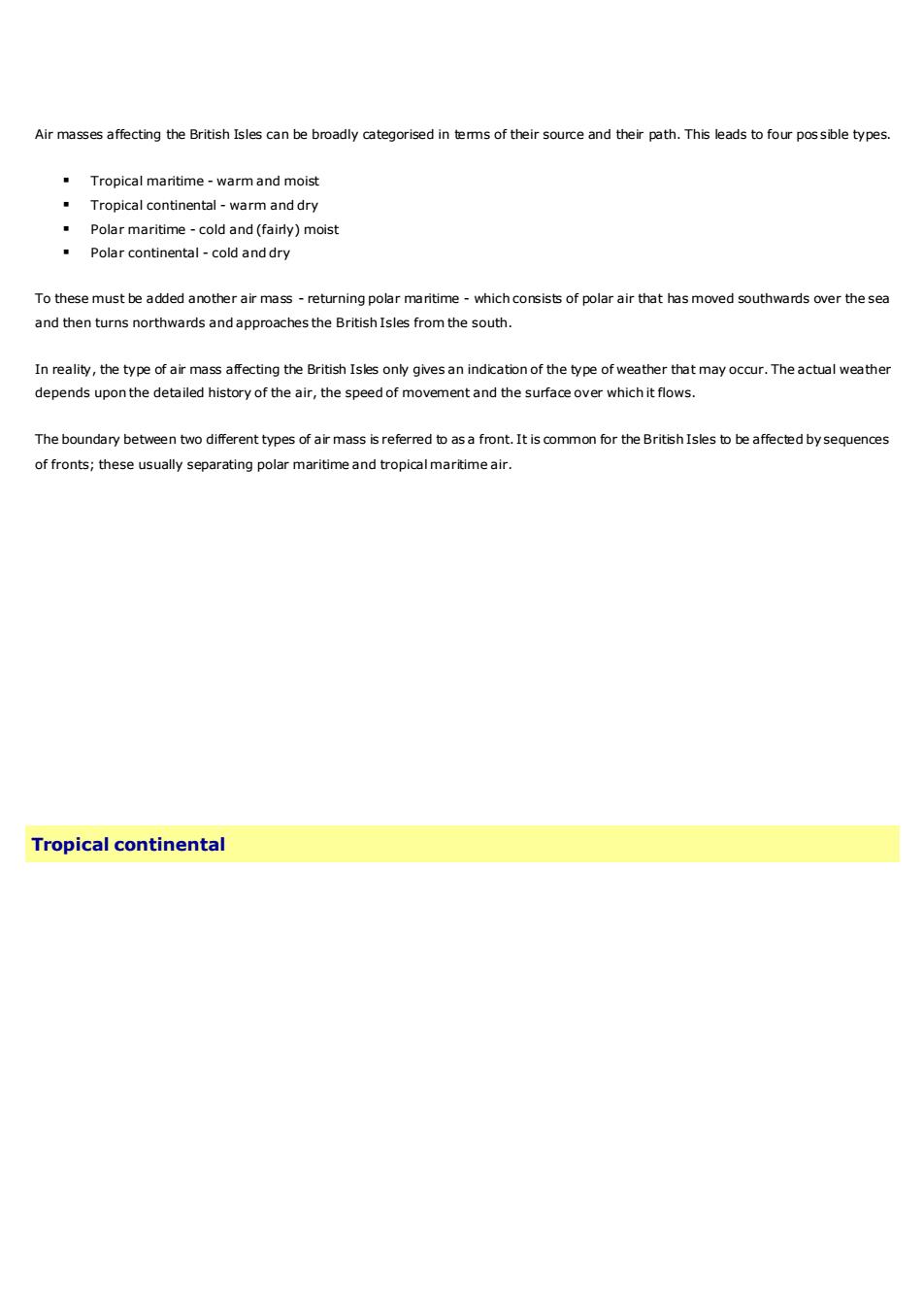
Tropical continental air usually comes with south-easterly or southerlyairstreams. It originates in North Africa and often travels over theMediterranean Sea, Spain and France before reaching the British Isles. Insummer, even easterly winds from central Europe or the Ukraine could beincluded in this category,as the continent becomes so hot at this time ofyear.The air picks up somemoisture over the Mediterranean (and perhapsSoutih orsouth-eastwindsbringtropicalthe Bay of Biscay),but overall the air tends to be quite dry and the skies arecontinental oirCtypicallycloudless.Strictlyspeaking,anairmasscooledfrombelowon itsnorthward journeyshould be stable.Sometimes,however,moisture may havefound its waytomedium levels in the atmosphere. Then, if there is a layer of unstable air anda trigger to set off convection, altocumulus castellanus clouds can develop,lookingliketurrets.Theseareoftentheforerunnertotremendousthunderstorms,whichcanoccurbydayornight.KThemajorityoftropicalcontinentalairstreamsgiveamarvellousheatwave(in summer), although plants and animals tend to be less appreciative of thistype of weather. The lack of moisture usually causes the visibility to be good.However,in the air there may be desertdust,fine soilor pollution particles,which can lead to moderate visibility(often describedas'heat haze').Also,thecloudlessskysometimeslooksmilkybecauseofpollutantsPolarcontinental
Tropical continental air usually comes with south-easterly or southerly airstreams. It originates in North Africa and often travels over the Mediterranean Sea, Spain and France before reaching the British Isles. In summer, even easterly winds from central Europe or the Ukraine could be included in this category, as the continent becomes so hot at this time of year. The air picks up some moisture over the Mediterranean (and perhaps the Bay of Biscay), but overall the air tends to be quite dry and the skies are typically cloudless. Strictly speaking, an air mass cooled from below on its northward journey should be stable. Sometimes, however, moisture may have found its way to medium levels in the atmosphere. Then, if there is a layer of unstable air and a trigger to set off convection, altocumulus castellanus clouds can develop, looking like turrets. These are often the forerunner to tremendous thunderstorms, which can occur by day or night. The majority of tropical continental airstreams give a marvellous heat wave (in summer), although plants and animals tend to be less appreciative of this type of weather. The lack of moisture usually causes the visibility to be good. However, in the air there may be desert dust, fine soil or pollution particles, which can lead to moderate visibility (often described as 'heat haze'). Also, the cloudless sky sometimes looks milky because of pollutants. Polar continental
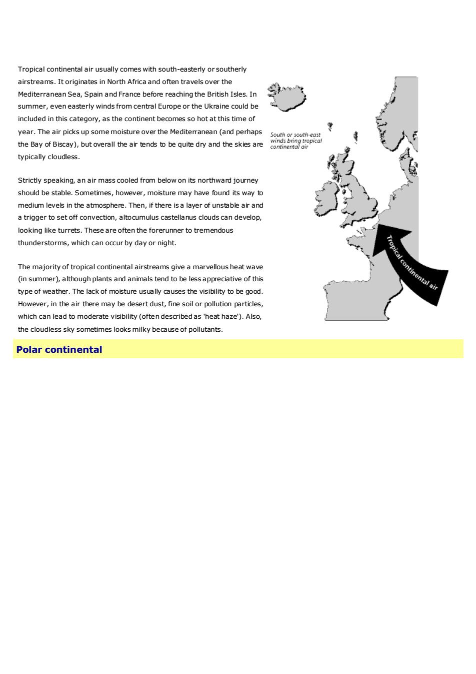
A polar continental air mass originates in Scandinavia or Russia,and the air massreaches the British Isles when north-easterly or easterly winds becomeestablished. This tends to occur when there is a high pressure area somewhere tothenorthoftheBritishIsles,oftenoverScandinaviaitself.Polarcontinentalainmasses mainly affect the British Isles during the winter half of the year.Temperatures inpolar continentalairmasses arebelowaverage in winter, exceptEost or north-eostwinds bring polarperhaps to the lee of mountains.In summer, however,the temperatures tend tocontinental Qirbe above average.Themoisture content is lowintheseairmasses,especiallywhen theytaketheshort sea track in the Calais/Doverregion.This leads to clouds being generally wellbroken, and so the weather is fine and sunny.Air that has crossed the North Seabetween Denmark and Scotland is said to havetakena long sea track.Itthereforecollects moremoisture and clouds tend to form during its journey over the sea.Consequently, it is cloudy in eastern districts (with perhaps drizzle or snowflurries), but furtherinland there tends to be a mixture of cloud and sunshine.Visibility varies, generally being very good when air comes from Scandinavia, butmoderate or poor when the air originates in the industrialised regions of central oreastern Europe. Even in Aprilor May,the North Sea is cold and does little to modifythe air mass,apart from adding a littie unwelcome moisture. Southern England isparticularly chilled by polar continental air masses. Further north the airstream isless coldandthewind isless strongTropicalmaritime
A polar continental air mass originates in Scandinavia or Russia, and the air mass reaches the British Isles when north-easterly or easterly winds become established. This tends to occur when there is a high pressure area somewhere to the north of the British Isles, often over Scandinavia itself. Polar continental air masses mainly affect the British Isles during the winter half of the year. Temperatures in polar continental air masses are below average in winter, except perhaps to the lee of mountains. In summer, however, the temperatures tend to be above average. The moisture content is low in these air masses, especially when they take the short sea track in the Calais/Dover region. This leads to clouds being generally well broken, and so the weather is fine and sunny. Air that has crossed the North Sea between Denmark and Scotland is said to have taken a long sea track. It therefore collects more moisture and clouds tend to form during its journey over the sea. Consequently, it is cloudy in eastern districts (with perhaps drizzle or snow flurries), but further inland there tends to be a mixture of cloud and sunshine. Visibility varies, generally being very good when air comes from Scandinavia, but moderate or poor when the air originates in the industrialised regions of central or eastern Europe. Even in April or May, the North Sea is cold and does little to modify the air mass, apart from adding a little unwelcome moisture. Southern England is particularly chilled by polar continental air masses. Further north the airstream is less cold and the wind is less strong. Tropical maritime
Tropical maritime air usually approaches the British Isles from the south-west.Its sourceregion is the subtropical Atlantic Ocean,typically the Azores area,although occasionally itmay come almost directly from the Caribbean. During its passage across the Atlantic, theair is cooled from belowas it passes overa progressively cooler ocean, and so it becomemore stable. While it cools down, little of its moisture is lost. It thereforereachessouth-west England or westem Ireland almost saturated,giving dull, warm, overcast1weather.South-westerfywindsbringropicamantmeLOn the coasts, sea fog is common in these tropical maritime south-westerlies. However, ifthe cloud base of the stratus or stratocumulus is several hundred feet, sea-level sites maybe saved from the fog, but on rising ground and hills there may be fog and drizzle. BodminMoor,Dartmoor,Dyfed,western Irelandand western Scotiland can be shrouded in mild,dampconditionswhetheritbewinterorsummer.Further inland,in the summer half of the yearat least, the low stratus maybe bumt off bythe sun and it could turn out to be quite warm, though still humid. In the lee of hills ormountainranges,thecloudssometimesbreakupandthereisalotofsunshine.Favouredlocations like north Somerset, North Wales, Northumberland and the Moray Firth can baskinspring-likeweatheronaJanuarydayIn a tropical maritime air mass, the nights are mild and damp, especially in mid-winter. InDecember and January the overcast skies result in there being little variation intemperature between day and night. However, if there are light winds and clear skies, fogmayform inlandovernight.Polarmaritime
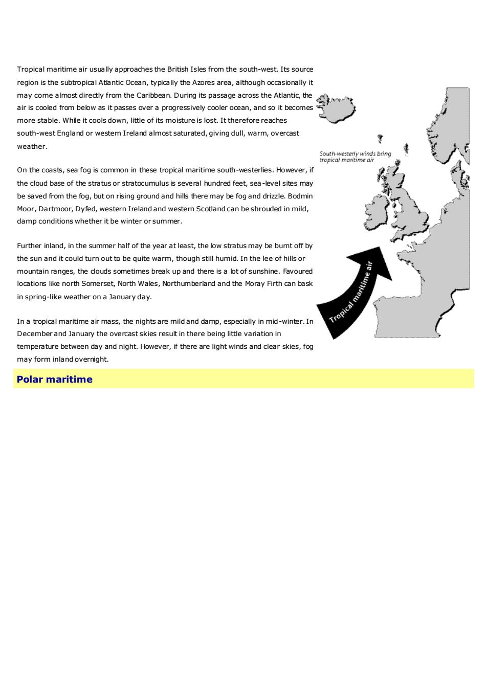
Tropical maritime air usually approaches the British Isles from the south-west. Its source region is the subtropical Atlantic Ocean, typically the Azores area, although occasionally it may come almost directly from the Caribbean. During its passage across the Atlantic, the air is cooled from below as it passes over a progressively cooler ocean, and so it becomes more stable. While it cools down, little of its moisture is lost. It therefore reaches south-west England or western Ireland almost saturated, giving dull, warm, overcast weather. On the coasts, sea fog is common in these tropical maritime south-westerlies. However, if the cloud base of the stratus or stratocumulus is several hundred feet, sea-level sites may be saved from the fog, but on rising ground and hills there may be fog and drizzle. Bodmin Moor, Dartmoor, Dyfed, western Ireland and western Scotland can be shrouded in mild, damp conditions whether it be winter or summer. Further inland, in the summer half of the year at least, the low stratus may be burnt off by the sun and it could turn out to be quite warm, though still humid. In the lee of hills or mountain ranges, the clouds sometimes break up and there is a lot of sunshine. Favoured locations like north Somerset, North Wales, Northumberland and the Moray Firth can bask in spring-like weather on a January day. In a tropical maritime air mass, the nights are mild and damp, especially in mid-winter. In December and January the overcast skies result in there being little variation in temperature between day and night. However, if there are light winds and clear skies, fog may form inland overnight. Polar maritime