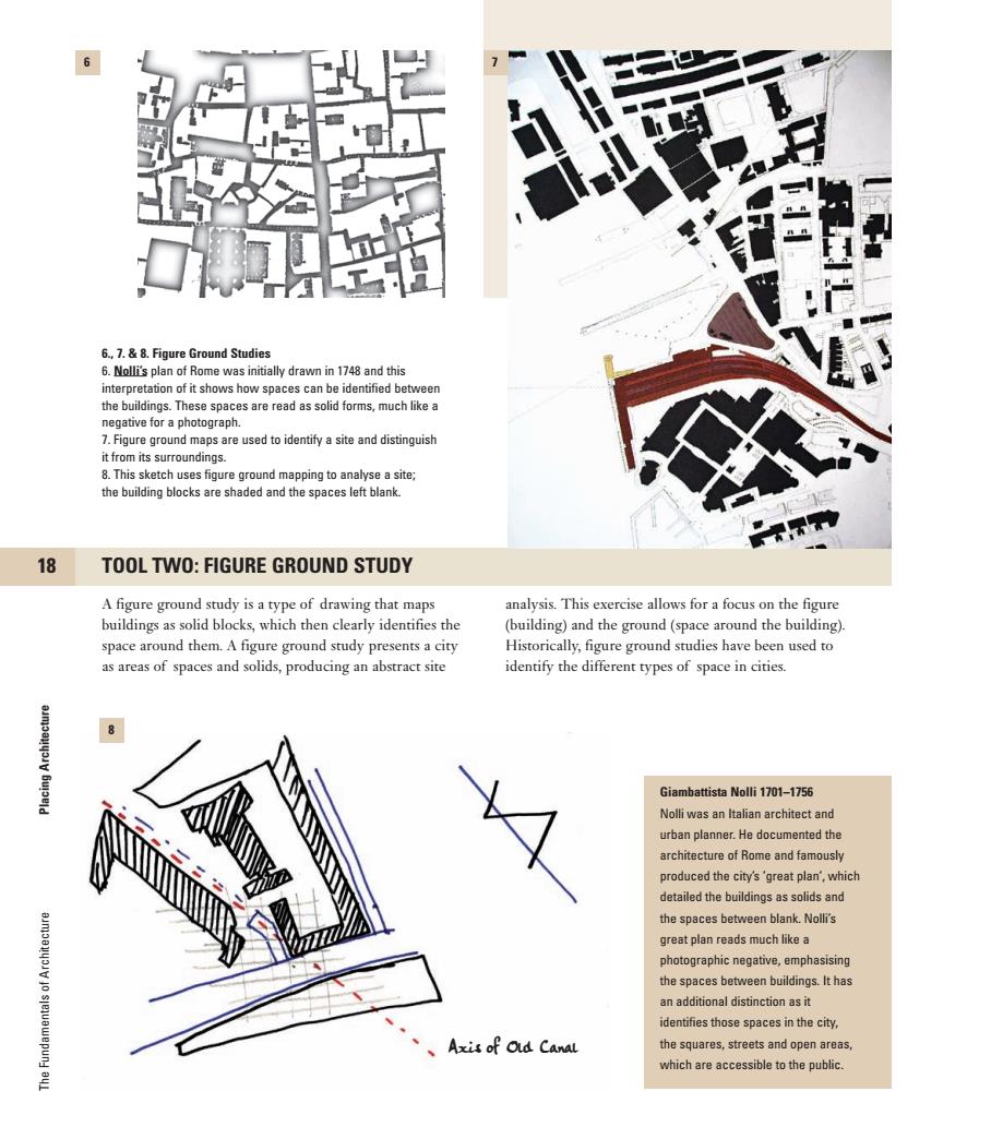
6 6.,7.&8.Figure Ground Studies 6.Nolli's plan of Rome was initially drawn in 1748 and this interpretation of it shows how spaces can be identified between the buildings.These spaces are read as solid forms,much like a negative for a photograph. 7.Figure ground maps are used to identify a site and distinguish it from its surroundings. 8.This sketch uses figure ground mapping to analyse a site; the building blocks are shaded and the spaces left blank. 18 TOOL TWO:FIGURE GROUND STUDY A figure ground study is a type of drawing that maps analysis.This exercise allows for a focus on the figure buildings as solid blocks,which then clearly identifies the (building)and the ground(space around the building). space around them.A figure ground study presents a city Historically,figure ground studies have been used to as areas of spaces and solids,producing an abstract site identify the different types of space in cities. Giambattista Nolli 1701-1756 Nolli was an Italian architect and urban planner.He documented the architecture of Rome and famously produced the city's'great plan,which detailed the buildings as solids and the spaces between blank.Nolli's great plan reads much like a photographic negative,emphasising the spaces between buildings.It has an additional distinction as it identifies those spaces in the city, Axis of Old Canal the squares,streets and open areas, which are accessible to the public
p18 J S D QC Preflight Point 2nd 11 11 Job no : 76451 Title : The Fundamentals of Architecture Client : AVA Scn : #175 Size : 200(w)230(h)mm Co : M11 C0 (All To Spot)(Coagl)__LC Dept : DTP D/O : 07.05.07 (Job no:76451C1 D/O : 25.05.07 Co: CM11) 76451_CTP_001-051.qxd 5/23/07 9:10 AM Page 18 p18 18Placing Architecture The Fundamentals of Architecture A figure ground study is a type of drawing that maps buildings as solid blocks, which then clearly identifies the space around them. A figure ground study presents a city as areas of spaces and solids, producing an abstract site analysis. This exercise allows for a focus on the figure (building) and the ground (space around the building). Historically, figure ground studies have been used to identify the different types of space in cities. 6., 7. & 8. Figure Ground Studies 6. Nolli’s plan of Rome was initially drawn in 1748 and this interpretation of it shows how spaces can be identified between the buildings. These spaces are read as solid forms, much like a negative for a photograph. 7. Figure ground maps are used to identify a site and distinguish it from its surroundings. 8. This sketch uses figure ground mapping to analyse a site; the building blocks are shaded and the spaces left blank. Giambattista Nolli 1701–1756 Nolli was an Italian architect and urban planner. He documented the architecture of Rome and famously produced the city’s ’great plan’, which detailed the buildings as solids and the spaces between blank. Nolli’s great plan reads much like a photographic negative, emphasising the spaces between buildings. It has an additional distinction as it identifies those spaces in the city, the squares, streets and open areas, which are accessible to the public. 6 8 7 TOOL TWO: FIGURE GROUND STUDY Axis of Old Canal 2nd (Job no:76451C1 D/O : 25.05.07 Co: CM11) 76451_CTP_001-051.qxd 5/23/07 9:10 AM Page 18
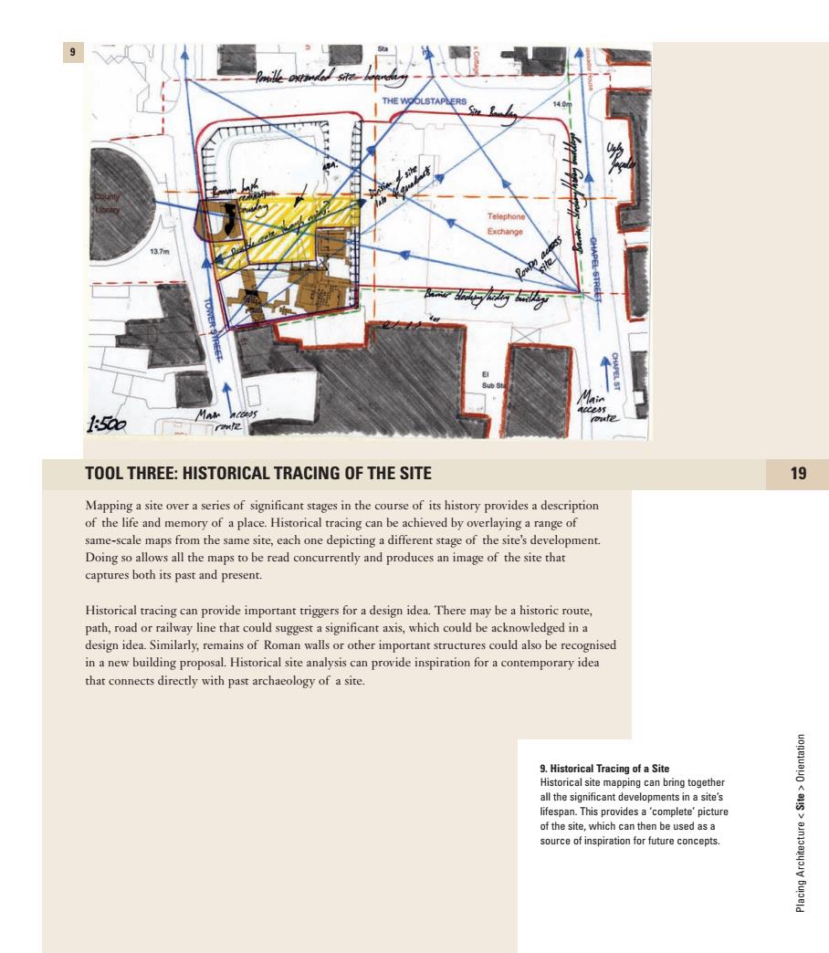
9 Telephone Exchange 137m 5如7me TOOL THREE:HISTORICAL TRACING OF THE SITE 19 Mapping a site over a series of significant stages in the course of its history provides a description of the life and memory of a place.Historical tracing can be achieved by overlaying a range of same-scale maps from the same site,each one depicting a different stage of the site's development. Doing so allows all the maps to be read concurrently and produces an image of the site that captures both its past and present. Historical tracing can provide important triggers for a design idea.There may be a historic route, path,road or railway line that could suggest a significant axis,which could be acknowledged in a design idea.Similarly,remains of Roman walls or other important structures could also be recognised in a new building proposal.Historical site analysis can provide inspiration for a contemporary idea that connects directly with past archaeology of a site 9.Historical Tracing of a Site Historical site mapping can bring together all the significant developments in a site's lifespan.This provides a 'complete'picture of the site,which can then be used as a source of inspiration for future concepts
QC Preflight Point 1st 11 11 Job no : 76451 Title : The Fundamentals of Architecture Client : AVA Scn : #175 Size : 200(w)230(h)mm Co : M11 C0 (All To Spot)(Coagl)__LC Dept : DTP D/O : 07.05.07 (Job no:000000 D/O : 00.00.07 Co: CM0) p19 74561_CTP_001-051.qxd 5/3/07 11:00 AM Page 19 1st TOOL THREE: HISTORICAL TRACING OF THE SITE 19 Mapping a site over a series of significant stages in the course of its history provides a description of the life and memory of a place. Historical tracing can be achieved by overlaying a range of same-scale maps from the same site, each one depicting a different stage of the site’s development. Doing so allows all the maps to be read concurrently and produces an image of the site that captures both its past and present. Historical tracing can provide important triggers for a design idea. There may be a historic route, path, road or railway line that could suggest a significant axis, which could be acknowledged in a design idea. Similarly, remains of Roman walls or other important structures could also be recognised in a new building proposal. Historical site analysis can provide inspiration for a contemporary idea that connects directly with past archaeology of a site. Placing Architecture < Site > Orientation 9. Historical Tracing of a Site Historical site mapping can bring together all the significant developments in a site’s lifespan. This provides a ‘complete’ picture of the site, which can then be used as a source of inspiration for future concepts. 9 p19 74561_CTP_001-051.qxd 5/3/07 11:00 AM Page 19

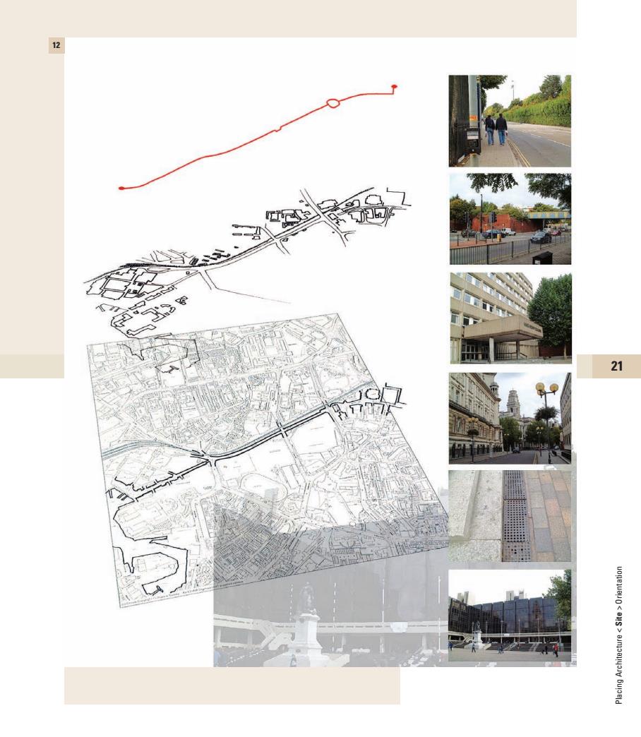
10 option Ol option OI ophion 03 20 SITE SURVEYS The condition of any site will need to be recorded in a survey.A survey can 10.,11.&12.Site Surveys be described as a record of something already in existence,and can be 10.This image depicts a series of options produced either in the form of a physical map or model,or a measured drawing for an urban scheme design described as a set of maps. that explains where doors,windows or boundaries exists,as well as specific 11.Physical surveys can be in the form of information such as relative heights of surrounding buildings,elevation a model or a map.A model can highlight details or heights of ground level across a site. specific characteristics of a site,such as aimoallyov the sea or a river. Detailed site analysis will measure physical aspects of the site.A site survey 12.This analysis of a journey through a city will provide dimensions of its width and depth and indicate any adjacent is displayed as a set of overlaid maps and Bujpeld photographic views.The maps are pulled building at the levels of plan,elevation and section(see page 100)to create apart and can be read as separate routes an accurate record of what currently exists.This is an essential part of the and journeys,isolating specific ideas. design process. Site surveys also can record different 'levels'.A level site survey shows the variations of contours and inclines and these may also be used to suggest ways in which to develop the design concept
QC Preflight Point 2nd 11 11 p20 Job no : 76451 Title : The Fundamentals of Architecture Client : AVA Scn : #175 Size : 200(w)230(h)mm Co : M11 C0 (All To Spot)(Coagl)__LC Dept : DTP D/O : 07.05.07 (Job no: 76451C1 D/O : 25.05.07 Co: CM3) J S D 76451_CTP_001-051.qxd 5/23/07 4:55 AM Page 20 2nd p20 Placing Architecture The Fundamentals of Architecture 10., 11. & 12. Site Surveys 10. This image depicts a series of options for an urban scheme design described as a set of maps. 11. Physical surveys can be in the form of a model or a map. A model can highlight specific characteristics of a site, such as the sea or a river. 12. This analysis of a journey through a city is displayed as a set of overlaid maps and photographic views. The maps are pulled apart and can be read as separate routes and journeys, isolating specific ideas. SITE SURVEYS The condition of any site will need to be recorded in a survey. A survey can be described as a record of something already in existence, and can be produced either in the form of a physical map or model, or a measured drawing that explains where doors, windows or boundaries exists, as well as specific information such as relative heights of surrounding buildings, elevation details or heights of ground level across a site. Detailed site analysis will measure physical aspects of the site. A site survey will provide dimensions of its width and depth and indicate any adjacent building at the levels of plan, elevation and section (see page 100) to create an accurate record of what currently exists. This is an essential part of the design process. Site surveys also can record different ‘levels’. A level site survey shows the variations of contours and inclines and these may also be used to suggest ways in which to develop the design concept. 20 10 11 option 01 option 01 option 03 76451_CTP_001-051.qxd 5/23/07 4:55 AM Page 20
12 21
p21 QC Preflight Point 3rd 11 11 Job no : 76451 Title : The Fundamentals of Architecture Client : AVA Scn : #175 Size : 200(w)230(h)mm Co : M11 C0 (All To Spot)(Coagl)__LC Dept : DTP D/O : 07.05.07 (Job no: 76451C3 D/O : 12.06.07 Co: CM11) 76451_CTP_001-051.qxd 6/12/07 4:50 PM Page 21 p21 3rd Placing Architecture < Site > Orientation 21 12 76451_CTP_001-051.qxd 6/12/07 4:50 PM Page 21
Orientation In terms of architecture and building,orientation describes an understanding of how a building's position on a site can influence specific factors concerning its design.How light affects our appreciation of buildings,and the activities we experience within them,is one of the most fundamental aspects of architectural design.Natural light in interior space brings life,a moving dimension and a connection with time and the outside. 22 POSITION Sites have specific and unique location qualities,and Design Orientation Factors this creates dynamic and ever-changing circumstances for 1. For living accommodation in the northern hemisphere,in anything positioned on it.For example,the shadow a design terms,bedrooms should be east facing and dining building projects will change from one day to the next, rooms west facing to enjoy the light from the rising and and the light quality in any room will continually move setting sun. and change. 2. South facing buildings will need some form of protection The position of a building relative to natural light from sunlight During summer months solar heat gain can determines many aspects of its planning.In a house, raise temperatures to uncomfortable levels.This the position of a garden terrace or the location of,say,a protection or modification can be in the form of internal dining room,rely on an architect's understanding of blinds or brise soleil (external projections that affect the how light enters a room or how shadow is cast across a light entering the building). garden.On larger scale buildings,orientation can significantly affect heat loss in winter and heat gain in 3 North light can provide constant and unvarying light. summer.This will affect the energy efficiency of the building and the comfort of its users. 4. Orientation is concerned with prevailing wind as well as sunlight,different aspects or elevations of buildings may The positioning of a building is part of the mechanics need to be treated in different ways to acknowledge this. of understanding the site,and it provides a changing varying impression of the site,from the point when the Buildings project shadows;understanding orientation sun rises to when it sets,and from the summer solstice requires an appreciation of the potential effect a building (when the sun is at its highest point),to the winter mass could have on its site or that of an adjacent one. solstice(when it is at its lowest). 黑
p22 J S D QC Preflight Point 2nd 11 11 Job no : 76451 Title : The Fundamentals of Architecture Client : AVA Scn : #175 Size : 200(w)230(h)mm Co : M11 C0 (All To Spot)(Coagl)__LC Dept : DTP D/O : 07.05.07 (Job no:76451C1 D/O : 25.05.07 Co: CM11) 76451_CTP_001-051.qxd 5/23/07 9:10 AM Page 22 p22 22Placing Architecture The Fundamentals of Architecture POSITION Sites have specific and unique location qualities, and this creates dynamic and ever-changing circumstances for anything positioned on it. For example, the shadow a building projects will change from one day to the next, and the light quality in any room will continually move and change. The position of a building relative to natural light determines many aspects of its planning. In a house, the position of a garden terrace or the location of, say, a dining room, rely on an architect’s understanding of how light enters a room or how shadow is cast across a garden. On larger scale buildings, orientation can significantly affect heat loss in winter and heat gain in summer. This will affect the energy efficiency of the building and the comfort of its users. The positioning of a building is part of the mechanics of understanding the site, and it provides a changing varying impression of the site, from the point when the sun rises to when it sets, and from the summer solstice (when the sun is at its highest point), to the winter solstice (when it is at its lowest). Orientation In terms of architecture and building, orientation describes an understanding of how a building’s position on a site can influence specific factors concerning its design. How light affects our appreciation of buildings, and the activities we experience within them, is one of the most fundamental aspects of architectural design. Natural light in interior space brings life, a moving dimension and a connection with time and the outside. Design Orientation Factors 1. For living accommodation in the northern hemisphere, in design terms, bedrooms should be east facing and dining rooms west facing to enjoy the light from the rising and setting sun. 2. South facing buildings will need some form of protection from sunlight. During summer months solar heat gain can raise temperatures to uncomfortable levels. This protection or modification can be in the form of internal blinds or brise soleil (external projections that affect the light entering the building). 3. North light can provide constant and unvarying light. 4. Orientation is concerned with prevailing wind as well as sunlight; different aspects or elevations of buildings may need to be treated in different ways to acknowledge this. 5. Buildings project shadows; understanding orientation requires an appreciation of the potential effect a building mass could have on its site or that of an adjacent one. 2nd (Job no:76451C1 D/O : 25.05.07 Co: CM11) 76451_CTP_001-051.qxd 5/23/07 9:10 AM Page 22