第37卷第2期 大气科学 Vol.37,No.2 2013年3月 Chinese Journal of Atmospheric Sciences Mar.2013 吴国雄,段安民,刘屹岷,等.2013.关于亚洲夏季风爆发的动力学研究的若干近期进展)大气科学,37(2211-228,doi:10.38785.iss.1006-98952012. 12312.Wu Guoxiong,Duan Anmin,Liu Yimin,et al.2013.Recent advances in the study on the dynamics of the Asian summer monsoon onset [J].Chinese Journal of Atmospheric Sciences (in Chinese),37(2):211-228. 关于亚洲夏季风爆发的动力学研究的若干近期进展 吴国雄1段安民1刘屹岷1颜京辉2刘伯奇13 任素玲4 张亚妮5王同美6梁潇云2关月5 1中国科学院大气物理研究所大气科学和地球流体力学数值模拟国家重点实验室(LASG),北京100029 2中国气象局国家气候中心,北京100081 3南京信息工程大学气象灾害省部共建教育部重点实验室(KLME),南京210044 4中国气象局国家卫星中心,北京100081 5中国气象局国家气象中心,北京100081 6中山大学大气科学系,广州510275 摘要资料分析显示,与850hPa风场相比,地面风的变化能更好地表征亚洲各季风系统的特征。基于地面风 的季节性反转和降水的显著变化所构建的亚洲夏季风(ASM)爆发指数和等时线图表明:亚洲热带夏季风(TASM) 在5月初首先在孟加拉湾(BOB)东南部爆发后不是向西传播,而是向东经中印半岛向东推进,于5月中到达中国南 海(SCS),6月初到达热带西北太平洋。印度夏季风的表面低压系统源于近赤道阿拉伯海地区,于6月初到达印度西 南部喀拉拉邦,印度夏季风随之爆发。亚洲副热带夏季风(STASM)5月初在西北太平洋日本本州东南的海区发生后 向西南伸展,于6月初与南海季风降水区连接,形成东北一西南向雨带,夏季风在中国东南沿海登陆,日本的“梅雨” (Baiu)开始。6月中该雨带向北到达长江流域和韩国,江淮梅雨和韩国的“梅雨”(Changma)开始。 本文还回顾了亚洲热带夏季风爆发的动力学研究的若干近期进展。春季青藏高原和南亚海陆分布的联合强迫 作用使海表温度(SST)在BOB中东部形成短暂但强盛的暖池,在高层南亚高压的抽吸作用下,常伴有季风爆发 涡旋(MOV)发展,使冬季连续带状的副高脊线在孟加拉湾东部断裂,导致亚洲热带季风首先在BOB爆发。BOB 东/西部有东/西风型垂直切变,利于激发/抑制对流活动,并增加/减少海洋向大气的表面感热加热,从而使得亚洲 夏季风爆发的向西传播在BOB西海岸遇到屏障。季风爆发逐渐向东伸展引发南海和热带西太平洋夏季风相继爆 发。季风降水释放的强大潜热使南亚高压发展西伸,纬向非对称位涡强迫显著增强:在阿拉伯半岛强烈的表面感 热加热所诱发的中层阿拉伯反气旋的共同作用下,位于阿拉伯海近赤道的低压系统北移发展成为季风爆发涡旋, 导致印度季风爆发。由此可见,历时约一个月的亚洲热带夏季风爆发的三个阶段(孟加拉湾、南海和印度季风爆 发)是发生在特定的地理环境下受特定的动力一热力学规律驱动的接续过程。 关键词青藏高原南亚高压纬向非对称位涡强迫孟加拉湾春季暖池季风爆发涡旋 文章编号1006-9895(2013)02-0211-18 中图分类号P433 文献标识码A doi10.3878.issn.1006-9895.2012.12312 Recent Advances in the Study on the Dynamics of the Asian Summer Monsoon Onset WU Guoxiong,DUAN Anmin',LIU Yimin,YAN Jinghui,LIU Boqi3 REN Suling',ZHANG Yanis,WANG Tongmei,LIANG Xiaoyun2,and GUAN Yue 收稿日期2012-10-15,2012-10-16收修定稿 资助项目科技部国家重点基础研究专项2010CB950403、2012CB417203,国家自然科学基金项目40925015、40875034、41275088、41175070、40975047 作者简介吴国雄,男,1943年出生,研究员,研究方向:天气、气候动力学。E-mail:gxwu@lasg.iap.ac.cn 通讯作者段安民,E-mail:amduan(@lasg.iap.ac.cn ?1994-2015 China Academic Journal Electronic Publishing House.All rights reserved.http://www.cnki.net
第 37 卷第 2 期 2013 年 3 月 大 气 科 学 Chinese Journal of Atmospheric Sciences Vol. 37, No. 2 Mar. 2013 吴国雄,段安民,刘屹岷,等. 2013. 关于亚洲夏季风爆发的动力学研究的若干近期进展 [J]. 大气科学, 37 (2): 211–228, doi:10.3878/j.issn.1006-9895.2012. 12312. Wu Guoxiong, Duan Anmin, Liu Yimin, et al. 2013. Recent advances in the study on the dynamics of the Asian summer monsoon onset [J]. Chinese Journal of Atmospheric Sciences (in Chinese), 37 (2): 211–228. 关于亚洲夏季风爆发的动力学研究的若干近期进展 吴国雄 1 段安民 1 刘屹岷 1 颜京辉 2 刘伯奇 1, 3 任素玲 4 张亚妮 5 王同美 6 梁潇云 2 关月 5 1 中国科学院大气物理研究所大气科学和地球流体力学数值模拟国家重点实验室(LASG),北京 100029 2 中国气象局国家气候中心,北京 100081 3 南京信息工程大学气象灾害省部共建教育部重点实验室(KLME),南京 210044 4 中国气象局国家卫星中心,北京 100081 5 中国气象局国家气象中心,北京 100081 6 中山大学大气科学系,广州 510275 摘 要 资料分析显示,与 850 hPa 风场相比,地面风的变化能更好地表征亚洲各季风系统的特征。基于地面风 的季节性反转和降水的显著变化所构建的亚洲夏季风(ASM)爆发指数和等时线图表明:亚洲热带夏季风(TASM) 在 5 月初首先在孟加拉湾(BOB)东南部爆发后不是向西传播,而是向东经中印半岛向东推进,于 5 月中到达中国南 海(SCS),6 月初到达热带西北太平洋。印度夏季风的表面低压系统源于近赤道阿拉伯海地区,于 6 月初到达印度西 南部喀拉拉邦,印度夏季风随之爆发。亚洲副热带夏季风(STASM)5 月初在西北太平洋日本本州东南的海区发生后 向西南伸展,于 6 月初与南海季风降水区连接,形成东北—西南向雨带,夏季风在中国东南沿海登陆,日本的“梅雨” (Baiu)开始。6 月中该雨带向北到达长江流域和韩国,江淮梅雨和韩国的“梅雨”(Changma) 开始。 本文还回顾了亚洲热带夏季风爆发的动力学研究的若干近期进展。春季青藏高原和南亚海陆分布的联合强迫 作用使海表温度(SST)在 BOB 中东部形成短暂但强盛的暖池,在高层南亚高压的抽吸作用下,常伴有季风爆发 涡旋(MOV)发展,使冬季连续带状的副高脊线在孟加拉湾东部断裂,导致亚洲热带季风首先在 BOB 爆发。BOB 东/西部有东/西风型垂直切变,利于激发/抑制对流活动,并增加/减少海洋向大气的表面感热加热,从而使得亚洲 夏季风爆发的向西传播在 BOB 西海岸遇到屏障。季风爆发逐渐向东伸展引发南海和热带西太平洋夏季风相继爆 发。季风降水释放的强大潜热使南亚高压发展西伸,纬向非对称位涡强迫显著增强;在阿拉伯半岛强烈的表面感 热加热所诱发的中层阿拉伯反气旋的共同作用下,位于阿拉伯海近赤道的低压系统北移发展成为季风爆发涡旋, 导致印度季风爆发。由此可见,历时约一个月的亚洲热带夏季风爆发的三个阶段(孟加拉湾、南海和印度季风爆 发)是发生在特定的地理环境下受特定的动力—热力学规律驱动的接续过程。 关键词 青藏高原 南亚高压 纬向非对称位涡强迫 孟加拉湾春季暖池 季风爆发涡旋 文章编号 1006–9895(2013)02–0211–18 中图分类号 P433 文献标识码 A doi:10.3878/j.issn.1006-9895.2012.12312 Recent Advances in the Study on the Dynamics of the Asian Summer Monsoon Onset WU Guoxiong1 , DUAN Anmin1 , LIU Yimin1 , YAN Jinghui2 , LIU Boqi1, 3, REN Suling4 , ZHANG Yani5 , WANG Tongmei6 , LIANG Xiaoyun2 , and GUAN Yue5 收稿日期 2012–10–15,2012–10–16 收修定稿 资助项目 科技部国家重点基础研究专项 2010CB950403、2012CB417203,国家自然科学基金项目 40925015、40875034、41275088、41175070、40975047 作者简介 吴国雄,男,1943 年出生,研究员,研究方向:天气、气候动力学。E-mail: gxwu@lasg.iap.ac.cn 通讯作者 段安民,E-mail: amduan@lasg.iap.ac.cn
大气科学 37卷 212 Chinese Journal of Atmospheric Sciences Vol.37 1 State Key Laboratory of Numerical Modeling for Atmospheric Sciences and Geophysical Fluid Dynamics (LASG),Institute of Atmospheric Physics, Chinese Academy of Sciences,Beijing 100029 2 National Climate Center,China Meteorological Administration,Beijing 100081 3 .Jiangsu Key Laboratory of Meteorological Disaster,Nanjing University of Information Science Technology,Nanjing 210044 4 National Satellite Meteorological Center,China Meteorological Administration,Beijing 100081 5 National Meteorological Center,China Meteorological Administration,Beijing 100081 6 Department of Atmospheric Sciences,Sun Yat-Sen University,Guangzhou 510275 Abstract The surface wind can be a better indicator of the onset of the Asian Summer Monsoon (ASM)system than the 850-hPa wind.The use of the new ASM onset index and analysis of pentad-isochrones,based on both the seasonal reversal of surface wind and the evident enhancement of rainfall,demonstrated that the onset of the Tropical Asian Summer Monsoon(TASM)first occurs over the southeastern Bay of Bengal(BOB)in May.It then propagates eastward to the Indochina Peninsula and reaches the South China Sea(SCS)in mid-May and the tropical North West Pacific (NWP) in early June.The surface depression of the Indian summer monsoon originates near the equatorial Arabian Sea,and then propagates northward to South Kerala in southwestern India in early June,indicating the onset of the Indian Summer Monsoon(ISM).In addition,the Subtropical Asian Summer Monsoon(STASM)is first formed over the NWP southeast of Honshu,Japan,and then it expands westward and merges into the precipitation zone of the SCS monsoon in early June, forming a northeast-southwest rainy belt.Almost at the same time,the summer monsoon reaches southeastern China and the Baiu in Japan also starts.In mid-June,the rainfall belt shifts northward to the Yangtze River and the Korean peninsula corresponding to the start of the Meiyu and Changma. This paper also reviews some recent progress in dynamics studies on the ASM onset.In spring,an evanescent but strong warm pool is formed in the central-eastern BOB due to the combined forcing of the Tibetan Plateau and the large-scale land-sea distribution in South Asia.Due to the coupling between this warm pool at the surface and the pumping effect of the South Asia High(SAH)in the upper troposphere,a Monsoon Onset Vortex(MOV)usually develops over the eastern BOB,breaking the ridgeline of the subtropical high that is continuous in winter,resulting in the first onset of TASM over the BOB.Furthermore,the vertical easterly/westerly shear over the eastern/western BOB prompts/inhibits the convection and increases/decreases the surface sensible heat transfer from ocean to atmosphere,resulting in a monsoon onset barrier over the west coast of the BOB that prevents the westward propagation of the monsoon onset. Hence,the monsoon onset can expand only eastward followed by the successive onset of the SCS and the tropical West Pacific summer monsoon.The strong latent heat released by the monsoon rainfall induces the westward development of the SAH and the conspicuous strengthening of zonal asymmetric potential vorticity (PV)forcing.Accompanied by the mid-troposphere anticyclone over the Arabian Peninsula stimulated by strong local surface sensible heating,the depression near the equatorial Arabian Sea moves northward and grows to a monsoon onset vortex,causing the ISM onset. Overall,the three phases(i.e.,the BOB,the SCS,and the Indian summer monsoon onset)of the TASM onset that persist for about one month can be considered as a consequential process driven by certain dynamic-thermodynamic rules covering a specific geographic environment,including the Tibetan Plateau and the land-sea distribution in South Asia. Keywords Tibetan Plateau,South Asia high,Zonal asymmetric PV forcing,BOB warm pool in spring,Monsoon onset vortex 1引言 来研究季风爆发(Wang et al.,2008),另有很多研 究则聚焦于季风爆发的过程(Ding,l992:Xie and 太阳高度角的年循环诱发了海一陆热力差异 Saiki,1999:Chang,2004:Wang,2006). 的季节变化(Webster et al.,1998)。季风则是由于 风和降水是定义季风爆发的两个基本物理量。 大气环流对海一陆热力差异季节变化的响应导致 与Ramage(1971)用1月和7月稳定持续的盛行 的天气变化,包括风场和降水的变化。季风爆发以 风反向定义季风区域不同,关于亚洲夏季风(ASM) 盛行风向的改变和剧烈降水的出现为特征。亚洲 爆发和演变的近期研究或用850hPa或700hPa风 季风的爆发预示着大气能量和水分循环的急速加 场的反向作为判据(Webster and Yang,l992:Wu and 强,并对社会和经济有重大影响。不同判据被提出 Zhang,1998:张永生和吴国雄,1998:Wang and Fan, ?1994-2015 China Academic Journal Electronic Publishing House.All rights reserved.http://www.cnki.net
大 气 科 学 Chinese Journal of Atmospheric Sciences 37 卷 212 Vol. 37 1 State Key Laboratory of Numerical Modeling for Atmospheric Sciences and Geophysical Fluid Dynamics (LASG), Institute of Atmospheric Physics, Chinese Academy of Sciences, Beijing 100029 2 National Climate Center, China Meteorological Administration, Beijing 100081 3 Jiangsu Key Laboratory of Meteorological Disaster, Nanjing University of Information Science & Technology, Nanjing 210044 4 National Satellite Meteorological Center, China Meteorological Administration, Beijing 100081 5 National Meteorological Center, China Meteorological Administration, Beijing 100081 6 Department of Atmospheric Sciences, Sun Yat-Sen University, Guangzhou 510275 Abstract The surface wind can be a better indicator of the onset of the Asian Summer Monsoon (ASM) system than the 850-hPa wind. The use of the new ASM onset index and analysis of pentad-isochrones, based on both the seasonal reversal of surface wind and the evident enhancement of rainfall, demonstrated that the onset of the Tropical Asian Summer Monsoon (TASM) first occurs over the southeastern Bay of Bengal (BOB) in May. It then propagates eastward to the Indochina Peninsula and reaches the South China Sea (SCS) in mid-May and the tropical North West Pacific (NWP) in early June. The surface depression of the Indian summer monsoon originates near the equatorial Arabian Sea, and then propagates northward to South Kerala in southwestern India in early June, indicating the onset of the Indian Summer Monsoon (ISM). In addition, the Subtropical Asian Summer Monsoon (STASM) is first formed over the NWP southeast of Honshu, Japan, and then it expands westward and merges into the precipitation zone of the SCS monsoon in early June, forming a northeast–southwest rainy belt. Almost at the same time, the summer monsoon reaches southeastern China and the Baiu in Japan also starts. In mid-June, the rainfall belt shifts northward to the Yangtze River and the Korean peninsula corresponding to the start of the Meiyu and Changma. This paper also reviews some recent progress in dynamics studies on the ASM onset. In spring, an evanescent but strong warm pool is formed in the central–eastern BOB due to the combined forcing of the Tibetan Plateau and the large-scale land–sea distribution in South Asia. Due to the coupling between this warm pool at the surface and the pumping effect of the South Asia High (SAH) in the upper troposphere, a Monsoon Onset Vortex (MOV) usually develops over the eastern BOB, breaking the ridgeline of the subtropical high that is continuous in winter, resulting in the first onset of TASM over the BOB. Furthermore, the vertical easterly/westerly shear over the eastern/western BOB prompts/inhibits the convection and increases/decreases the surface sensible heat transfer from ocean to atmosphere, resulting in a monsoon onset barrier over the west coast of the BOB that prevents the westward propagation of the monsoon onset. Hence, the monsoon onset can expand only eastward followed by the successive onset of the SCS and the tropical West Pacific summer monsoon. The strong latent heat released by the monsoon rainfall induces the westward development of the SAH and the conspicuous strengthening of zonal asymmetric potential vorticity (PV) forcing. Accompanied by the mid-troposphere anticyclone over the Arabian Peninsula stimulated by strong local surface sensible heating, the depression near the equatorial Arabian Sea moves northward and grows to a monsoon onset vortex, causing the ISM onset. Overall, the three phases (i.e., the BOB, the SCS, and the Indian summer monsoon onset) of the TASM onset that persist for about one month can be considered as a consequential process driven by certain dynamic–thermodynamic rules covering a specific geographic environment, including the Tibetan Plateau and the land–sea distribution in South Asia. Keywords Tibetan Plateau, South Asia high, Zonal asymmetric PV forcing, BOB warm pool in spring, Monsoon onset vortex 1 引言 太阳高度角的年循环诱发了海—陆热力差异 的季节变化(Webster et al.,1998)。季风则是由于 大气环流对海—陆热力差异季节变化的响应导致 的天气变化,包括风场和降水的变化。季风爆发以 盛行风向的改变和剧烈降水的出现为特征。亚洲 季风的爆发预示着大气能量和水分循环的急速加 强,并对社会和经济有重大影响。不同判据被提出 来研究季风爆发(Wang et al.,2008),另有很多研 究则聚焦于季风爆发的过程(Ding, 1992;Xie and Saiki,1999;Chang,2004;Wang,2006)。 风和降水是定义季风爆发的两个基本物理量。 与 Ramage(1971)用 1 月和 7 月稳定持续的盛行 风反向定义季风区域不同,关于亚洲夏季风(ASM) 爆发和演变的近期研究或用 850 hPa 或 700 hPa 风 场的反向作为判据(Webster and Yang,1992;Wu and Zhang,1998;张永生和吴国雄,1998;Wang and Fan
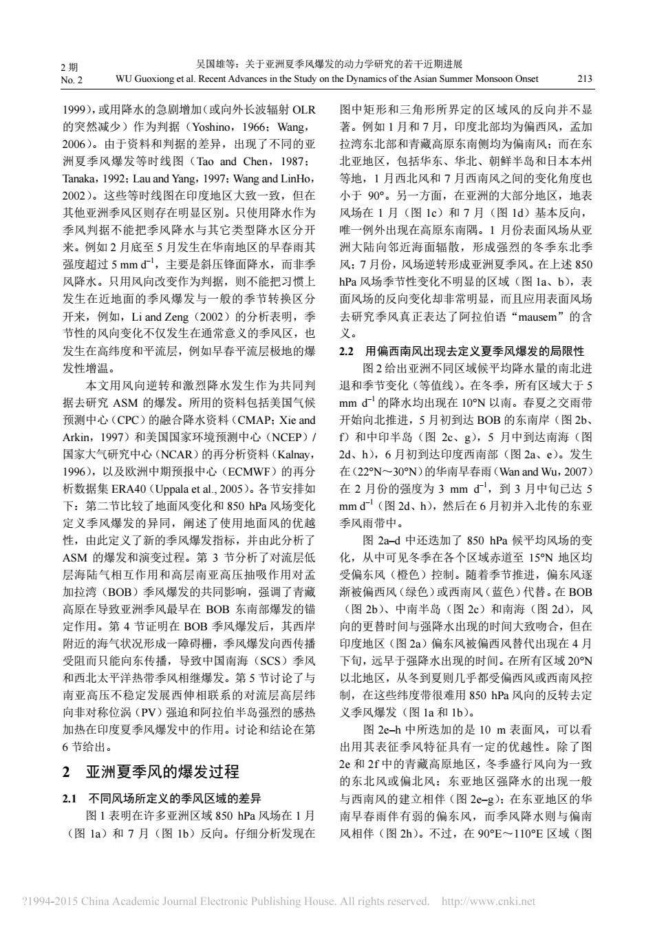
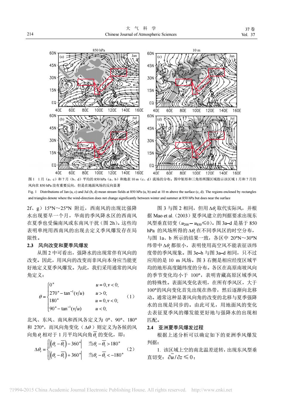
2期 吴国雄等:关于亚洲夏季风爆发的动力学研究的若干近期进展 No.2 WU Guoxiong et al.Recent Advances in the Study on the Dynamics of the Asian Summer Monsoon Onset 213 1999),或用降水的急剧增加(或向外长波辐射OLR 图中矩形和三角形所界定的区域风的反向并不显 的突然减少)作为判据(Yoshino,1966:Wang, 著。例如1月和7月,印度北部均为偏西风,孟加 2006)。由于资料和判据的差异,出现了不同的亚 拉湾东北部和青藏高原东南侧均为偏南风:而在东 洲夏季风爆发等时线图(Tao and Chen,1987: 北亚地区,包括华东、华北、朝鲜半岛和日本本州 Tanaka,1992:Lau and Yang,1997:Wang and LinHo, 等地,1月西北风和7月西南风之间的变化角度也 2002)。这些等时线图在印度地区大致一致,但在 小于90°。另一方面,在亚洲的大部分地区,地表 其他亚洲季风区则存在明显区别。只使用降水作为 风场在1月(图1c)和7月(图1d)基本反向, 季风判据不能把季风降水与其它类型降水区分开 唯一例外出现在高原东南隅。1月份表面风场从亚 来。例如2月底至5月发生在华南地区的早春雨其 洲大陆向邻近海面辐散,形成强烈的冬季东北季 强度超过5mmd,主要是斜压锋面降水,而非季 风:7月份,风场逆转形成亚洲夏季风。在上述850 风降水。只用风向改变作为判据,则不能把习惯上 hPa风场季节性变化不明显的区域(图1a、b),表 发生在近地面的季风爆发与一般的季节转换区分 面风场的反向变化却非常明显,而且应用表面风场 开来,例如,Li and Zeng(2002)的分析表明,季 去研究季风真正表达了阿拉伯语“mausem”的含 节性的风向变化不仅发生在通常意义的季风区,也 义。 发生在高纬度和平流层,例如早春平流层极地的爆 2.2用偏西南风出现去定义夏季风爆发的局限性 发性增温。 图2给出亚洲不同区域候平均降水量的南北进 本文用风向逆转和激烈降水发生作为共同判 退和季节变化(等值线)。在冬季,所有区域大于5 据去研究ASM的爆发。所用的资料包括美国气候 mmd的降水均出现在10N以南。春夏之交雨带 预测中心(CPC)的融合降水资料(CMAP:Xie and 开始向北推进,5月初到达BOB的东南岸(图2b、 Arkin,1997)和美国国家环境预测中心(NCEP)/ f)和中印半岛(图2c、g),5月中到达南海(图 国家大气研究中心(NCAR)的再分析资料(Kalnay, 2d、h),6月初到达印度西南部(图2a、e)。发生 1996),以及欧洲中期预报中心(ECMWF)的再分 在(22N~30N)的华南早春雨(Wan and Wu,.2007) 析数据集ERA40(Uppala et al.,2005)。各节安排如 在2月份的强度为3mmd,到3月中旬己达5 下:第二节比较了地面风变化和850hPa风场变化 mmd(图2d、h),然后在6月初并入北传的东亚 定义季风爆发的异同,阐述了使用地面风的优越 季风雨带中。 性,由此定义了新的季风爆发指标,并由此分析了 图2a-d中还迭加了850hPa候平均风场的变 ASM的爆发和演变过程。第3节分析了对流层低 化,从中可见冬季在各个区域赤道至15N地区均 层海陆气相互作用和高层南亚高压抽吸作用对孟 受偏东风(橙色)控制。随着季节推进,偏东风逐 加拉湾(BOB)季风爆发的共同影响,强调了青藏 渐被偏西风(绿色)或西南风(蓝色)代替。在BOB 高原在导致亚洲季风最早在BOB东南部爆发的锚 (图2b)、中南半岛(图2c)和南海(图2d),风 定作用。第4节证明在BOB季风爆发后,其西岸 向的更替时间与强降水出现的时间大致吻合,但在 附近的海气状况形成一障碍栅,季风爆发向西传播 印度地区(图2a)偏东风被偏西风替代出现在4月 受阻而只能向东传播,导致中国南海(SCS)季风 下旬,远早于强降水出现的时间。在所有区域20N 和西北太平洋热带季风相继爆发。第5节讨论了与 以北地区,从冬到夏则几乎都受偏西风或西南风控 南亚高压不稳定发展西伸相联系的对流层高层纬 制,在这些纬度带很难用850hPa风向的反转去定 向非对称位涡(PV)强迫和阿拉伯半岛强烈的感热 义季风爆发(图1a和1b)。 加热在印度夏季风爆发中的作用。讨论和结论在第 图2e-h中所迭加的是10m表面风,可以看 6节给出。 出用其表征季风特征具有一定的优越性。除了图 2 亚洲夏季风的爆发过程 2e和2f中的青藏高原地区,冬季盛行风向为一致 的东北风或偏北风:东亚地区强降水的出现一般 2.1不同风场所定义的季风区域的差异 与西南风的建立相伴(图2e-g):在东亚地区的华 图1表明在许多亚洲区域850hPa风场在1月 南早春雨伴有弱的偏东风,而季风降水则与偏南 (图1a)和7月(图1b)反向。仔细分析发现在 风相伴(图2h)。不过,在90E~110E区域(图 ?1994-2015 China Academic Journal Electronic Publishing House.All rights reserved.http://www.cnki.net
2 期 No. 2 吴国雄等:关于亚洲夏季风爆发的动力学研究的若干近期进展 WU Guoxiong et al. Recent Advances in the Study on the Dynamics of the Asian Summer Monsoon Onset 213 1999),或用降水的急剧增加(或向外长波辐射 OLR 的突然减少)作为判据(Yoshino,1966;Wang, 2006)。由于资料和判据的差异,出现了不同的亚 洲夏季风爆发等时线图(Tao and Chen,1987; Tanaka,1992;Lau and Yang,1997;Wang and LinHo, 2002)。这些等时线图在印度地区大致一致,但在 其他亚洲季风区则存在明显区别。只使用降水作为 季风判据不能把季风降水与其它类型降水区分开 来。例如 2 月底至 5 月发生在华南地区的早春雨其 强度超过 5 mm d–1,主要是斜压锋面降水,而非季 风降水。只用风向改变作为判据,则不能把习惯上 发生在近地面的季风爆发与一般的季节转换区分 开来,例如,Li and Zeng(2002)的分析表明,季 节性的风向变化不仅发生在通常意义的季风区,也 发生在高纬度和平流层,例如早春平流层极地的爆 发性增温。 本文用风向逆转和激烈降水发生作为共同判 据去研究 ASM 的爆发。所用的资料包括美国气候 预测中心(CPC)的融合降水资料(CMAP;Xie and Arkin,1997)和美国国家环境预测中心(NCEP)/ 国家大气研究中心(NCAR)的再分析资料(Kalnay, 1996),以及欧洲中期预报中心(ECMWF)的再分 析数据集 ERA40(Uppala et al., 2005)。各节安排如 下:第二节比较了地面风变化和 850 hPa 风场变化 定义季风爆发的异同,阐述了使用地面风的优越 性,由此定义了新的季风爆发指标,并由此分析了 ASM 的爆发和演变过程。第 3 节分析了对流层低 层海陆气相互作用和高层南亚高压抽吸作用对孟 加拉湾(BOB)季风爆发的共同影响,强调了青藏 高原在导致亚洲季风最早在 BOB 东南部爆发的锚 定作用。第 4 节证明在 BOB 季风爆发后,其西岸 附近的海气状况形成一障碍栅,季风爆发向西传播 受阻而只能向东传播,导致中国南海(SCS)季风 和西北太平洋热带季风相继爆发。第 5 节讨论了与 南亚高压不稳定发展西伸相联系的对流层高层纬 向非对称位涡(PV)强迫和阿拉伯半岛强烈的感热 加热在印度夏季风爆发中的作用。讨论和结论在第 6 节给出。 2 亚洲夏季风的爆发过程 2.1 不同风场所定义的季风区域的差异 图 1 表明在许多亚洲区域 850 hPa 风场在 1 月 (图 1a)和 7 月(图 1b)反向。仔细分析发现在 图中矩形和三角形所界定的区域风的反向并不显 著。例如 1 月和 7 月,印度北部均为偏西风,孟加 拉湾东北部和青藏高原东南侧均为偏南风;而在东 北亚地区,包括华东、华北、朝鲜半岛和日本本州 等地,1 月西北风和 7 月西南风之间的变化角度也 小于 90°。另一方面,在亚洲的大部分地区,地表 风场在 1 月(图 1c)和 7 月(图 1d)基本反向, 唯一例外出现在高原东南隅。1 月份表面风场从亚 洲大陆向邻近海面辐散,形成强烈的冬季东北季 风;7 月份,风场逆转形成亚洲夏季风。在上述 850 hPa 风场季节性变化不明显的区域(图 1a、b),表 面风场的反向变化却非常明显,而且应用表面风场 去研究季风真正表达了阿拉伯语“mausem”的含 义。 2.2 用偏西南风出现去定义夏季风爆发的局限性 图 2 给出亚洲不同区域候平均降水量的南北进 退和季节变化(等值线)。在冬季,所有区域大于 5 mm d–1 的降水均出现在 10°N 以南。春夏之交雨带 开始向北推进,5 月初到达 BOB 的东南岸(图 2b、 f)和中印半岛(图 2c、g),5 月中到达南海(图 2d、h),6 月初到达印度西南部(图 2a、e)。发生 在(22°N~30°N)的华南早春雨(Wan and Wu,2007) 在 2 月份的强度为 3 mm d–1,到 3 月中旬已达 5 mm d–1(图 2d、h),然后在 6 月初并入北传的东亚 季风雨带中。 图 2a–d 中还迭加了 850 hPa 候平均风场的变 化,从中可见冬季在各个区域赤道至 15°N 地区均 受偏东风(橙色)控制。随着季节推进,偏东风逐 渐被偏西风(绿色)或西南风(蓝色)代替。在 BOB (图 2b)、中南半岛(图 2c)和南海(图 2d),风 向的更替时间与强降水出现的时间大致吻合,但在 印度地区(图 2a)偏东风被偏西风替代出现在 4 月 下旬,远早于强降水出现的时间。在所有区域 20°N 以北地区,从冬到夏则几乎都受偏西风或西南风控 制,在这些纬度带很难用 850 hPa 风向的反转去定 义季风爆发(图 1a 和 1b)。 图 2e–h 中所迭加的是 10 m 表面风,可以看 出用其表征季风特征具有一定的优越性。除了图 2e 和 2f 中的青藏高原地区,冬季盛行风向为一致 的东北风或偏北风;东亚地区强降水的出现一般 与西南风的建立相伴(图 2e–g);在东亚地区的华 南早春雨伴有弱的偏东风,而季风降水则与偏南 风相伴(图 2h)。不过,在 90°E~110°E 区域(图
大气科学 37卷 214 Chinese Journal of Atmospheric Sciences Vol.37 850 hPa 60N 60N 45N 45N 30N 30N 5 EQ EQ 40E 60E 80E 100E120E140E160E 40E 60E 80E 100E120E 140E160E 60N (d) 45 45N 50N 30N 15N 15N EQ EQ 40E60E80E100E120E140E160E 40E 60E 80E100E120E140E160E 图11月(a、c)和7月(b、d)平均的850hPa(a、b)和地表10m(c、d)流场的分布。图中矩形和三角形所围区域指示该区域1月和7月的 风向在850hPa没有重要反向,但是在地面风场的反向显著 Fig.I Distributions of Jan (a,c)and Jul (b,d)mean stream fields at 850 hPa (a,b)and at 10 m above the surface (c,d).The regions enclosed by rectangles and triangles denote where the wind-direction does not change significantly between winter and summer at 850 hPa but does near the surface 2f、g)15N~25N附近,西南风的出现比强降 图3与图2相同,但用△0取代实际风,并根 水出现要早一个月,华南的季风降水区的西南风 据Mao et al..(2003)夏季风建立的判据要求出现东 在夏季也受偏南风或东南风干扰(图2h)。这些均 风型垂直切变(山200-g0≤0)。图3a-d是基于850 表明单纯用西南风的出现去定义季风爆发存在局 hPa的风场所得的△日.在不同季风区的时空分布, 限性。 与图1a、b所示的结果一致,各区中20N~30N 2.3风向改变和夏季风爆发 纬带中△日都很小,表明使用高空风不能表征该纬 从图2中可看出,强降水的出现常伴有风向的 度带的季风现象。图3e-h与图3a-d相同,只不过 改变。因此,用风向的改变而非风向本身应当能更 应用的是10m风场。图3右侧是相应经度区域平 好地定义夏季风爆发。为此,我们采用通常的风向 均的地形高度随纬度的分布。各区在高原南坡风向 角定义: 的季节变化均小于100°,表明青藏高原区域季风 0 u=0,v<0 的特殊性。表面风变化表明,在所有季风区,大于 270°-tan-'(v/uw) u>0 100°的风向变化首先出现在热带,然后逐渐向北移 0= (1) 180° 动。通常这种显著风向角的改变的北移与夏季强降 u=0,v<0: 90°-tan-(v/w)) 水的出现是同步的。由此可见,用地面风的变化 u<0 去表征夏季风的爆发能更好地与强降水的出现相 北风、东风、南风和西风各定义为0°、90°、180° 匹配。 和270°,而风向角变化(△0)则定义为各候的风 2.4亚洲夏季风爆发过程 向角日相对于1月平均风向角日的变化,即: 根据上述分析可以确定如下的亚洲季风爆发 (8-8-360当8-8>180° 判据: △8,= (2) 1.该区域上空的南北温差逆转,出现东风型垂 8,-8+360当8,-日<-180 直切变:ou/az≤0: ?1994-2015 China Academic Journal Electronic Publishing House.All rights reserved.http://www.cnki.net
大 气 科 学 Chinese Journal of Atmospheric Sciences 37 卷 214 Vol. 37 2f、g)15°N~25°N 附近,西南风的出现比强降 水出现要早一个月,华南的季风降水区的西南风 在夏季也受偏南风或东南风干扰(图 2h)。这些均 表明单纯用西南风的出现去定义季风爆发存在局 限性。 2.3 风向改变和夏季风爆发 从图 2 中可看出,强降水的出现常伴有风向的 改变。因此,用风向的改变而非风向本身应当能更 好地定义夏季风爆发。为此,我们采用通常的风向 角定义: 1 1 0 270 tan ( ) 180 0, 0; 0; 0, 0; 90 tan 0; ( ) u v u v v u u u u v ° ° ° ° (1) 北风、东风、南风和西风各定义为 0°、90°、180° 和 270°,而风向角变化( )则定义为各候的风 向角t 相对于 1 月平均风向角1 的变化,即: 1 1 1 1 80 360 1 360 80 1 t t t t t ° ° ° 当 ° 当 (2) 图 3 与图 2 相同,但用 t 取代实际风,并根 据 Mao et al.(2003)夏季风建立的判据要求出现东 风型垂直切变(u200 – u850≤0)。图 3a–d 是基于 850 hPa 的风场所得的 t 在不同季风区的时空分布, 与图 1a、b 所示的结果一致,各区中 20°N~30°N 纬带中 t 都很小,表明使用高空风不能表征该纬 度带的季风现象。图 3e–h 与图 3a–d 相同,只不过 应用的是 10 m 风场。图 3 右侧是相应经度区域平 均的地形高度随纬度的分布。各区在高原南坡风向 的季节变化均小于 100°,表明青藏高原区域季风 的特殊性。表面风变化表明,在所有季风区,大于 100°的风向变化首先出现在热带,然后逐渐向北移 动。通常这种显著风向角的改变的北移与夏季强降 水的出现是同步的。由此可见,用地面风的变化 去表征夏季风的爆发能更好地与强降水的出现相 匹配。 2.4 亚洲夏季风爆发过程 根据上述分析可以确定如下的亚洲季风爆发 判据: 1. 该区域上空的南北温差逆转,出现东风型垂 直切变: u z / 0 ≤ ; 图 1 1 月(a、c)和 7 月(b、d)平均的 850 hPa(a、b)和地表 10 m(c、d)流场的分布。图中矩形和三角形所围区域指示该区域 1 月和 7 月的 风向在 850 hPa 没有重要反向,但是在地面风场的反向显著 Fig. 1 Distributions of Jan (a, c) and Jul (b, d) mean stream fields at 850 hPa (a, b) and at 10 m above the surface (c, d). The regions enclosed by rectangles and triangles denote where the wind-direction does not change significantly between winter and summer at 850 hPa but does near the surface
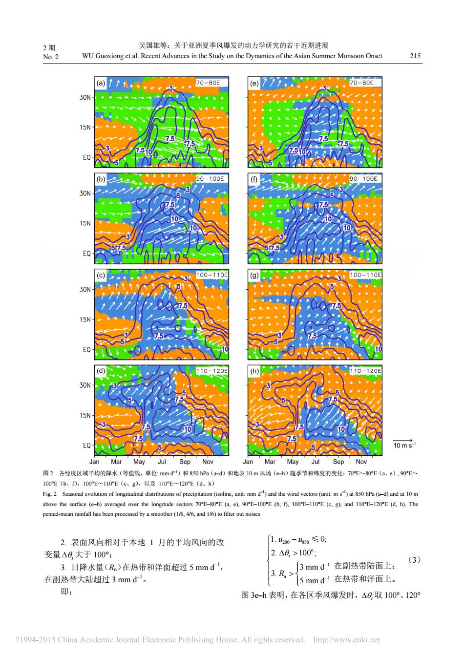
2期 吴国雄等:关于亚洲夏季风爆发的动力学研究的若干近期进展 No.2 WU Guoxiong et al.Recent Advances in the Study on the Dynamics of the Asian Summer Monsoon Onset 215 (a)tttrr3 70-80E (e) 70-80E 30N 15N (b 90-100E (⑤ 30N 15N 100-110E g 110E 30N 7 15N 7.5 110-120E (h) 120E 30N 15N 10ms1 Jan Mar May Jul Sep Nov Jan Mar May Jul Sep Nov 图2各经度区域平均的降水(等值线,单位:mmd)和850hPa(a-d)和地表10m风场(e-h)随季节和纬度的变化:70E~80E(a、e),90E~ 100E(b、f),100E~110E(c、g),以及110E~120E(d、h) Fig.2 Seasonal evolution of longitudinal distributions of precipitation (isoline,unit:mm d)and the wind vectors (unit:m s")at 850 hPa (a-d)and at 10 m above the surface (e-h)averaged over the longitude sectors 70E-80E (a,e),90E-100E(b,f),100E-110E (c,g),and 110E-120E (d,h).The pentad-mean rainfall has been processed by a smoother (1/6,4/6,and 1/6)to filter out noises 2.表面风向相对于本地1月的平均风向的改 1.42o0-4g50≤0 变量△8,大于100°: 2.△0,>100° (3) 3.日降水量(Rn)在热带和洋面超过5mmd, 3mmd1在副热带陆面上: 在副热带大陆超过3mmd。 3.R> 5mmd~在热带和洋面上。 即: 图3e-h表明,在各区季风爆发时,△0,取100°、120° ?1994-2015 China Academic Journal Electronic Publishing House.All rights reserved.http://www.cnki.net
2 期 No. 2 吴国雄等:关于亚洲夏季风爆发的动力学研究的若干近期进展 WU Guoxiong et al. Recent Advances in the Study on the Dynamics of the Asian Summer Monsoon Onset 215 图 2 各经度区域平均的降水(等值线,单位: mm d–1)和 850 hPa(a–d)和地表 10 m 风场(e–h)随季节和纬度的变化:70°E~80°E(a、e), 90°E~ 100°E(b、f),100°E~110°E(c、g),以及 110°E~120°E(d、h) Fig. 2 Seasonal evolution of longitudinal distributions of precipitation (isoline, unit: mm d–1) and the wind vectors (unit: m s–1) at 850 hPa (a–d) and at 10 m above the surface (e–h) averaged over the longitude sectors 70°E–80°E (a, e), 90°E–100°E (b, f), 100°E–110°E (c, g), and 110°E–120°E (d, h). The pentad-mean rainfall has been processed by a smoother (1/6, 4/6, and 1/6) to filter out noises 2. 表面风向相对于本地 1 月的平均风向的改 变量 t 大于 100°; 3. 日降水量(Rn)在热带和洋面超过 5 mm d–1, 在副热带大陆超过 3 mm d–1。 即: 200 850 o 1 n 1 1. 0; 2. 100 ; 3 mm d 3. 5 mm d t u u R ≤ (3) 图 3e–h 表明,在各区季风爆发时,t 取 100°、120° 在副热带陆面上; 在热带和洋面上