《地质地貌学》课程教学大纲(2020版) 课程基本信息(Course Information) 课程代码 *学时 学分 (Course Code) (Credits) 课程名称 地质地貌学 Cours Name) Geological geomorphology 理程性西 专业类选修课 (Course Type) 授课对象 农业资源与环境、农水、水保、土木专业类本科生 (Audicnce) 授课语言 Language o文 Instruction) 开课院系 (School) 农业与生物学院 先修课程 矿物学,地质学原理,土 (Prerequisite)学,生态学等 授课教师 课程网址 康宏樟 (Course Webpage) 课程性质:《地质地貌学》是研究地壳的物质组成,地表形态发生、发展的一门自然 科学。地质地貌学与士壤学、水文学等课程关系密切,相辅相成。又是环境影响评价、荒 化防治工程、流域管理、水士保持等课程的先修课。 《地质地貌学》是农业资源与环境 等本科学生的一门重要的专业课程。 主要敕学内容:该课程重点介绍了地球基本特性、地壳的物质组成、三大岩石的形成 演化过程、地壳运动形成的地质构造与构造地貌、各种外力地质作用过程及相应的沉积物 课程简介(中和地貌、地质地貌和农业生产、环境、自然旅游等的关系。主要内容包括:地球的字宙 境、地壳的组成物质系统、地质构造的研究、风化作用系统、重力地貌系统、地面流水的 Description) 地质作用及地貌特征、地下水的地质作用及水资源评价、风的地质作用及水土流失综合治 厘、冰川的地质作用及地貌特征、冻土地貌的形成及特征、研究湖沼与海洋的地质作用及 地貌的重要意义、自然旅游地学资源的研究、土端环境系统、植被对环境的影响、地质男 境系统、“数字地球产生的时代背量及应用示范。 学目标:通过本课程的学习,使学生系统全面地了解和掌握地质地貌学的基础知识 基本理论和研究方法。掌握坡地重力地貌、流水地貌、岩溶地貌、黄土地貌、荒漠地貌、 陈土地貌等的形态特征、成因、分布及其滴变规律。培养学生地学思维能力、地质和地貌
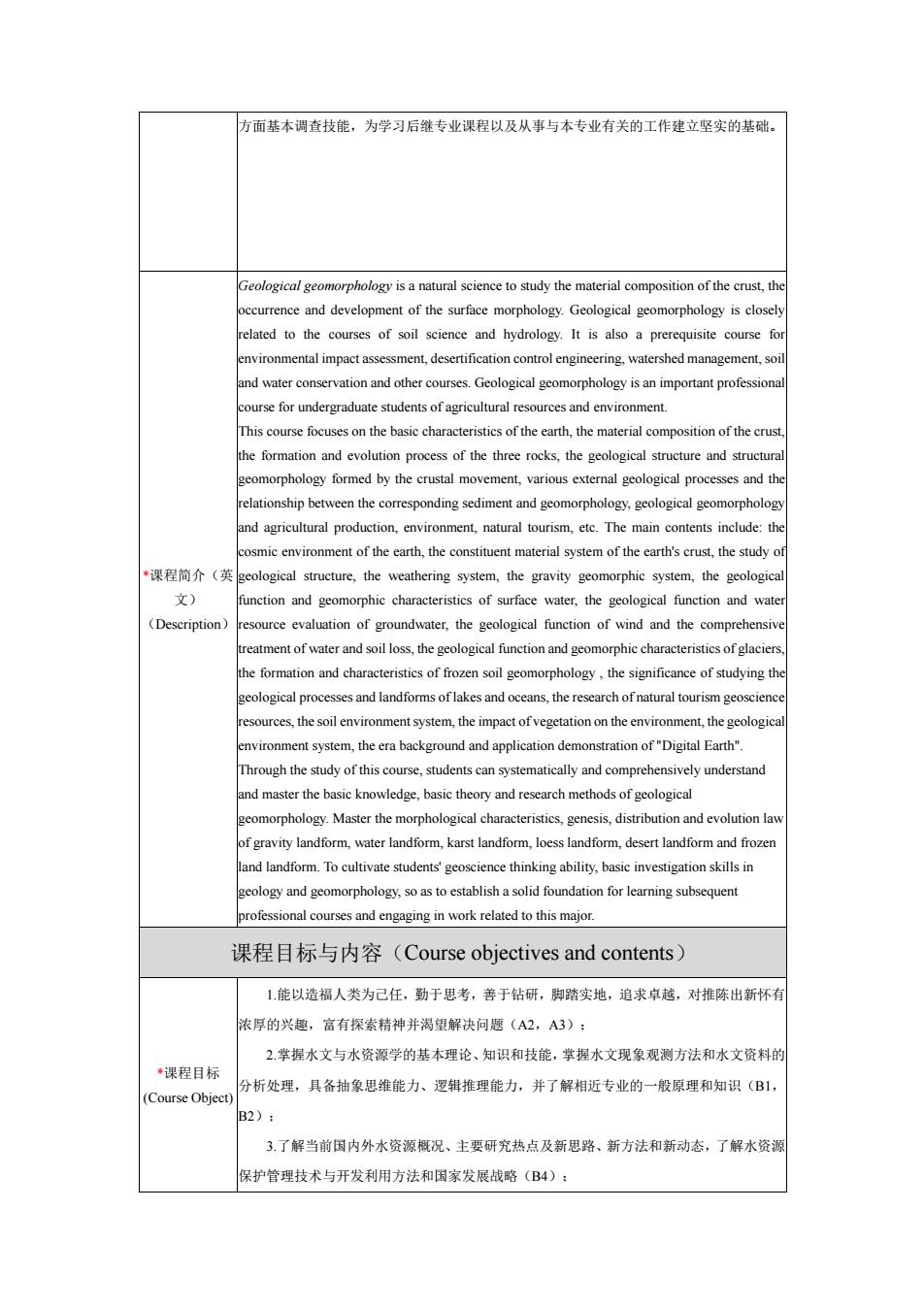
《地质地貌学》课程教学大纲(2020 版) 课程基本信息(Course Information) 课程代码 (Course Code) ECOL4404 *学时 (Credit Hours) 32 *学分 (Credits) 2 *课程名称 ( Course Name) 地质地貌学 Geological geomorphology 课程性质 (Course Type) 专业类选修课 授课对象 (Audience) 农业资源与环境、农水、水保、土木专业类本科生 授课语言 (Language of Instruction) 中文 *开课院系 (School) 农业与生物学院 先修课程 (Prerequisite) 矿物学,地质学原理,土壤 学,生态学等 授课教师 (Instructor) 康宏樟 课程网址 (Course Webpage) 无 *课程简介(中 文) (Description) 课程性质:《地质地貌学》是研究地壳的物质组成,地表形态发生、发展的一门自然 科学。地质地貌学与土壤学、水文学等课程关系密切,相辅相成。又是环境影响评价、荒 漠化防治工程、流域管理、水土保持等课程的先修课。《地质地貌学》是农业资源与环境 等本科学生的一门重要的专业课程。 主要教学内容:该课程重点介绍了地球基本特性、地壳的物质组成、三大岩石的形成 演化过程、地壳运动形成的地质构造与构造地貌、各种外力地质作用过程及相应的沉积物 和地貌、地质地貌和农业生产、环境、自然旅游等的关系。主要内容包括:地球的宇宙环 境、地壳的组成物质系统、地质构造的研 究、风化作用系统、重力地貌系统、地面流水的 地质作用及地貌特征、地下水的地质作用及水资源评价、风的地质作用及水土流失综合治 理、冰川的地质作用及地貌特征、冻土地貌的形成及特征、研究湖沼与海洋的地质作用及 地貌的重要意义、自然旅游地学资源的研究、土壤环境系统、植被对环境的影响、地质环 境系统、“数字地球”产生的时代背景及应用示范。 教学目标:通过本课程的学习,使学生系统全面地了解和掌握地质地貌学的基础知识、 基本理论和研究方法。掌握坡地重力地貌、流水地貌、岩溶地貌、黄土地貌、荒漠地貌、 冻土地貌等的形态特征、成因、分布及其演变规律。培养学生地学思维能力、地质和地貌

方而基本调杏技能,为学习后珠专业课程以及从事与本专业有关的工作建立坚实的基础 occurrence and development of the surface morphology.Geological geomorphology is close related to the courses of soil science and hydrology It is also a prerequisite course fo environmental impact assessment.desertification control engineering.watershed management.s This course focuses on the basic characteristics of the earth,the material composition of the crus the formation and evolution process of the three rocks.the geological structure and structus geomorphology formed by the crustal movement,various external geological processes and th relationship between the corresponding sediment and geomorphology,geological geomorpholog and agricultural natural.Theman n:th of.the material system of theth'scusthe study *课程简介(英 eological structure.the weathering system,the gravity geomorphic system,the geologic 文) function and geomorphic characteristics of surface water.the geological function and wat (Description) urce evaluation of groundwater,the geological function of wind and the comprehensiv on and charact cs of frozen soil geomorphology,the significance of studying t cological processes and landforms oflakes and oceans,the research of natural tourism geoscie esources.the soil environment system.the impact of vegetation on the environment.the geologic environment system,the era background and application demonstration of"Digital Earth". hrough the study of this course students can systematically and comprebensively understand nd m ter the basie knowedge.basic theory and methods of geological of gravity landform,water landform,karst landform,loess landform,desert landform and frozer land landform.To cultivate students'geoscience thinking ability,basic investigation skills in cology and geomorphology.so as to establish a solid foundation for learning subsequent 课程目标与内容(Course objectives and contents) 1,能以造福人类为己任,勤于思考,善于钻研,脚踏实地,追求卓越,对推陈出新怀 浓厚的兴趣,富有探索精神并渴望解决问愿(A2,A3): 2.拳握水文与水资源学的基本理论、知识和技能,掌握水文现象观测方法和水文资料的 课程目标 分析处理,具备抽象思维能力、逻辑推理能力,并了解相近专业的一般原理和知识(B1 Course Object B2): 3.了解当前国内外水资源概况、主要研究热点及新思路、新方法和新动态,了解水资溪 保护管理技术与开发利用方法和国家发展战略(B4):
方面基本调查技能,为学习后继专业课程以及从事与本专业有关的工作建立坚实的基础。 *课程简介(英 文) (Description) Geological geomorphology is a natural science to study the material composition of the crust, the occurrence and development of the surface morphology. Geological geomorphology is closely related to the courses of soil science and hydrology. It is also a prerequisite course for environmental impact assessment, desertification control engineering, watershed management, soil and water conservation and other courses. Geological geomorphology is an important professional course for undergraduate students of agricultural resources and environment. This course focuses on the basic characteristics of the earth, the material composition of the crust, the formation and evolution process of the three rocks, the geological structure and structural geomorphology formed by the crustal movement, various external geological processes and the relationship between the corresponding sediment and geomorphology, geological geomorphology and agricultural production, environment, natural tourism, etc. The main contents include: the cosmic environment of the earth, the constituent material system of the earth's crust, the study of geological structure, the weathering system, the gravity geomorphic system, the geological function and geomorphic characteristics of surface water, the geological function and water resource evaluation of groundwater, the geological function of wind and the comprehensive treatment of water and soil loss, the geological function and geomorphic characteristics of glaciers, the formation and characteristics of frozen soil geomorphology , the significance of studying the geological processes and landforms of lakes and oceans, the research of natural tourism geoscience resources, the soil environment system, the impact of vegetation on the environment, the geological environment system, the era background and application demonstration of "Digital Earth". Through the study of this course, students can systematically and comprehensively understand and master the basic knowledge, basic theory and research methods of geological geomorphology. Master the morphological characteristics, genesis, distribution and evolution law of gravity landform, water landform, karst landform, loess landform, desert landform and frozen land landform. To cultivate students' geoscience thinking ability, basic investigation skills in geology and geomorphology, so as to establish a solid foundation for learning subsequent professional courses and engaging in work related to this major. 课程目标与内容(Course objectives and contents) *课程目标 (Course Object) 1.能以造福人类为己任,勤于思考,善于钻研,脚踏实地,追求卓越,对推陈出新怀有 浓厚的兴趣,富有探索精神并渴望解决问题(A2,A3); 2.掌握水文与水资源学的基本理论、知识和技能,掌握水文现象观测方法和水文资料的 分析处理,具备抽象思维能力、逻辑推理能力,并了解相近专业的一般原理和知识(B1, B2); 3.了解当前国内外水资源概况、主要研究热点及新思路、新方法和新动态,了解水资源 保护管理技术与开发利用方法和国家发展战略(B4);

。4堂提资料奇询、文献检索及运用现代信自技术获得相关信息的基本方法,具各一定的 水文实验设计、论文撰写和学术交流能力:有较强的终身自学能力和分析解决问题 能力,以及适应社会多方面需求的能力和发展浩力(C5), 作业及老 教学内容(要点) 学时 教学形式 课程思政融入对应课程 核要求 标 了解地: 125 地貌学别 究的对兔 任务:掌提 地质地貌 学的研习 地质地貌学研究的 去为公 对象和任务、地质地 点:树立地 研究进展,培 1 质地貌学 貌学的特点和研究 1课堂讲授 养学生爱闲情 方法。 怀以及责任 理解地质 教学内容讲度 地貌学的 安排及对应误 含义及抗 程目标(Ca 和农业资 Schedule 源与环境 Requirements 的关系。 Course 了解地球 Objectives) A 大小、形 状、磁场、 温度及其 地质意义: 理解地球 内部、外部 地球在宇宙中的位 培养学生的探 及其相质精神,引号 层构造 2 课堂讲授 关系:掌据 学生建立正确 壳及地质作用 地质作用的宇宙瘦 的含义及 其分类,重 层构造:地 质作用的
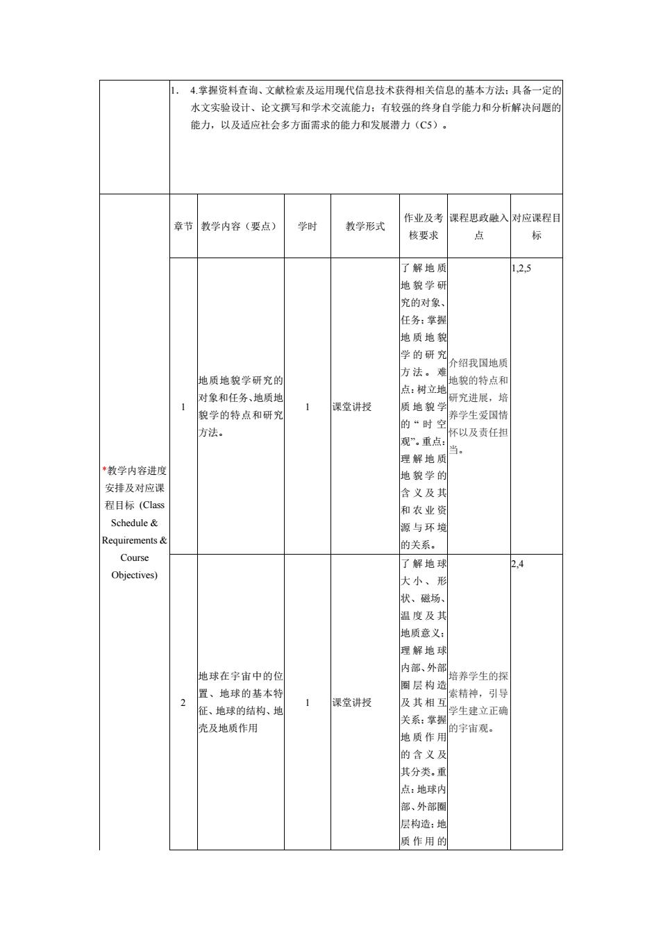
1. 4.掌握资料查询、文献检索及运用现代信息技术获得相关信息的基本方法;具备一定的 水文实验设计、论文撰写和学术交流能力;有较强的终身自学能力和分析解决问题的 能力,以及适应社会多方面需求的能力和发展潜力(C5)。 *教学内容进度 安排及对应课 程目标 (Class Schedule & Requirements & Course Objectives) 章节 教学内容(要点) 学时 教学形式 作业及考 核要求 课程思政融入 点 对应课程目 标 1 地质地貌学研究的 对象和任务、地质地 貌学的特点和研究 方法。 1 课堂讲授 了解地质 地貌学研 究的对象、 任务;掌握 地质地貌 学的研究 方法。难 点:树立地 质地貌学 的 “ 时 空 观”。重点: 理解地质 地貌学的 含义及其 和农业资 源与环境 的关系。 介绍我国地质 地貌的特点和 研究进展,培 养学生爱国情 怀以及责任担 当。 1,2,5 2 地球在宇宙中的位 置、地球的基本特 征、地球的结构、地 壳及地质作用 1 课堂讲授 了解地球 大小、形 状、磁场、 温度及其 地质意义; 理解地球 内部、外部 圈层构造 及其相互 关系;掌握 地质作用 的含义及 其分类。重 点:地球内 部、外部圈 层构造;地 质作用的 培养学生的探 索精神,引导 学生建立正确 的宇宙观。 2,4

含义及 点:四大 相互作用 关系及其 影响。 534 解矿物的 含义及其 成因,物 的公米. 物的认识 方法及常 见矿物的 典型特征: 三大岩石 的成因及 其相互转 化:岩石的 分类、认识 方法及常 +控游时想的 型特征区玉石产品 见岩石的 广物的基本特征、 物的分类和主要 如何鉴定直 重点:矿为 物、矿物的识别和 课堂讲授 的认识方假,防止上当 受骗?”,通 用、岩浆岩(火成 法及常见 岩)、沉积岩、变质 物的奥让专业 过学习和实 型特征: 大岩石的 识更加贴近生 成因及其底 相互转化: 岩石的认 识方法及 征,难点: 矿物的品 体构造及 其对矿物 性质的 响:三大岩 石的结构 与构造特 征岩浆岩
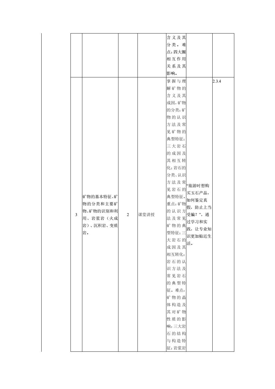
含义及其 分类。难 点:四大圈 相互作用 关系及其 影响。 3 矿物的基本特征、矿 物的分类和主要矿 物、矿物的识别和利 用、岩浆岩(火成 岩)、沉积岩、变质 岩。 2 课堂讲授 掌握与理 解矿物的 含义及其 成因,矿物 的分类;矿 物的认识 方法及常 见矿物的 典型特征; 三大岩石 的成因及 其相互转 化;岩石的 分类、认识 方法及常 见岩石的 典型特征。 重点:矿物 的认识方 法及常见 矿物的典 型特征;三 大岩石的 成因及其 相互转化; 岩石的认 识方法及 常见岩石 的典型特 征。难点: 矿物的晶 体构造及 其对矿物 性质的影 响;三大岩 石的结构 与构造特 征;岩浆岩 “旅游时想购 买玉石产品, 如何鉴定真 假,防止上当 受骗?”,通 过学习和实 践,让专业知 识更加贴近生 活。 2.3.4

的生成环 镜与结构 构造的关 了地声 运动的 般特征, 质年代确 定方法:理 螺抽县舍 义及地历 年代:草列 地壳运云 及其对地 质地貌产 生的影响 地壳运动 与地质构 造的关系 地壳运动的一般结 各种地历 认识自然的力 征、地层年代和岩月 构造特征 量,培养学生 产状、帮皱构造、断 裂构造、构造地貌 尊重自然规 主要类型与特征,区 域地壳稳定性研究 6 课堂讲授 象及块,提自 然,规范个人卫3 构造与 的发展方向、地震 质作用 行为,以身作 地质构造与土填,水 土保持的关系、地质 失系。重义核心价值 测,弘扬社会 点:地壳运 图的阅读, 动及其对 地质地貌 产生的影 响:地壳运 系:各种坦 质构造特 征及构造 造现象的 分析:板块 构造与地 质作用的 关系
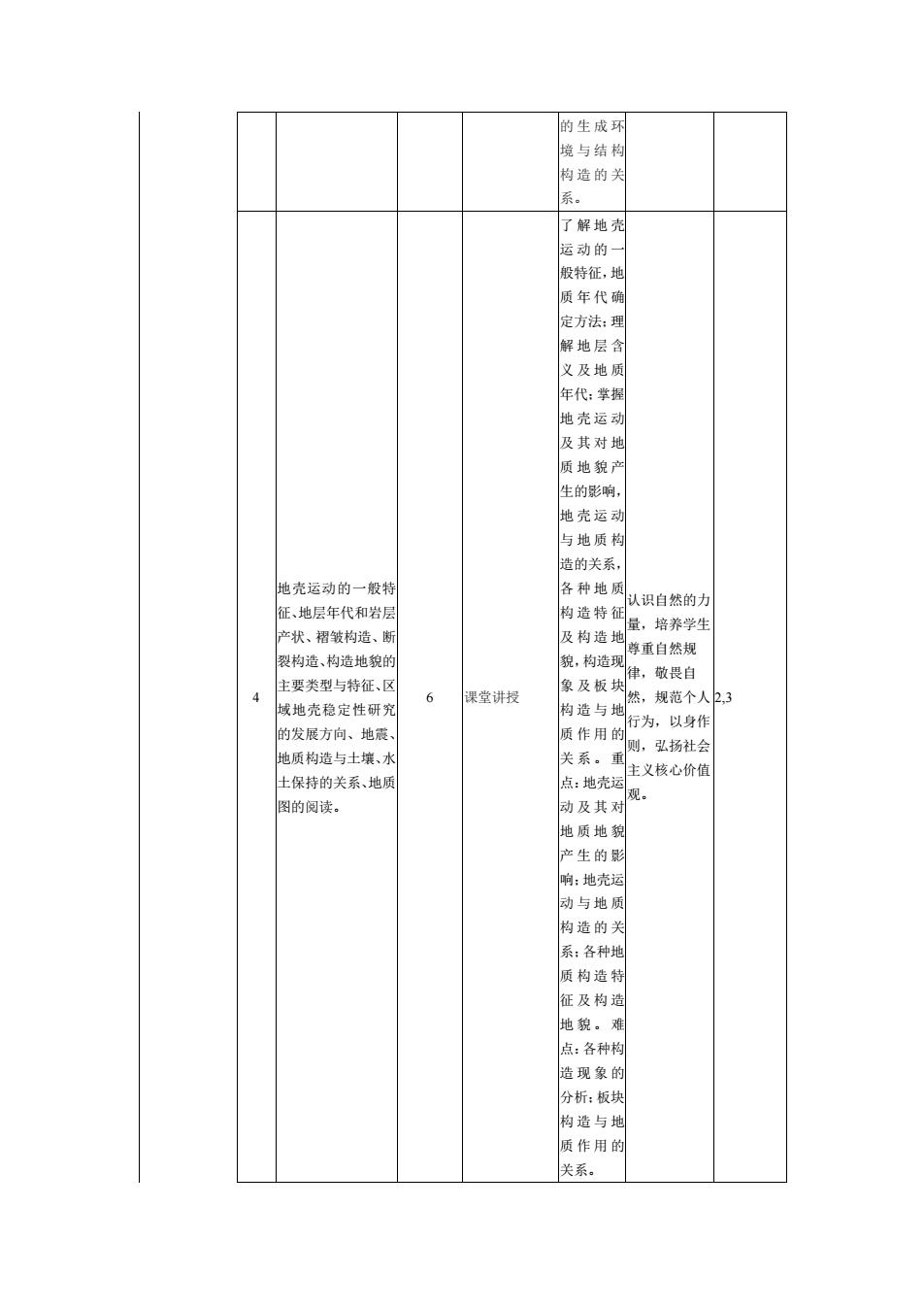
的生成环 境与结构 构造的关 系。 4 地壳运动的一般特 征、地层年代和岩层 产状、褶皱构造、断 裂构造、构造地貌的 主要类型与特征、区 域地壳稳定性研究 的发展方向、地震、 地质构造与土壤、水 土保持的关系、地质 图的阅读。 6 课堂讲授 了解地壳 运动的一 般特征,地 质年代确 定方法;理 解地层含 义及地质 年代;掌握 地壳运动 及其对地 质地貌产 生的影响, 地壳运动 与地质构 造的关系, 各种地质 构造特征 及构造地 貌,构造现 象及板块 构造与地 质作用的 关系。重 点:地壳运 动及其对 地质地貌 产生的影 响;地壳运 动与地质 构造的关 系;各种地 质构造特 征及构造 地貌。难 点:各种构 造现象的 分析;板块 构造与地 质作用的 关系。 认识自然的力 量,培养学生 尊重自然规 律,敬畏自 然,规范个人 行为,以身作 则,弘扬社会 主义核心价值 观。 2,3